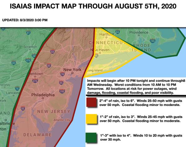
Tonight through Tomorrow Morning
Look for scattered showers and thunderstorms to start to develop after 9 PM tonight and increase in coverage through tomorrow morning. There will be breaks in the rainfall, but these thunderstorms will be capable of some very heavy downpours and wind gusts over 40 mph at times. Rainfall rates of 0.50" to 1.00" per hour will be possible. Don't let your guard down in between these breaks in the rainfall as you can go from 8+ miles
visibility to below 1 mile in a very short period of time.
Tomorrow Afternoon And Evening
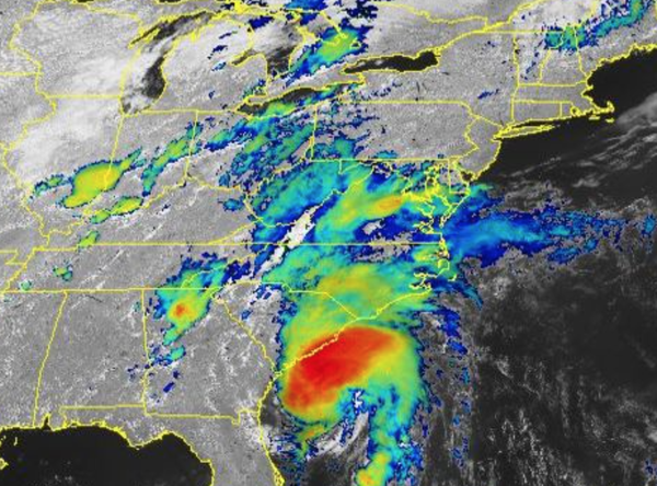
The core of Isaias will track from eastern Virginia to the Philadelphia metro and then towards the Hudson River Valley. The rain shield will be in a state of change as the storm structure goes from purely tropical to subtropical, which means the rain shield will expand while there will be intense pockets of rain, rainfall rates 1" to 3" per hour, on the northeastern to the northwestern side of the circulation, which is basically in the red areas of
the forecast. Meanwhile, sustained winds will increase to 25 to 50 mph with gusts potentially up to hurricane strength. The worst impacts right now are likely to be between 1o AM to 10 PM tomorrow. Minor to moderate coastal flooding will be a threat. There will be a high threat for coastal flooding, urban/river flooding, poor visibility, tornadoes, and wind damage. Power outages and disruptions to travel can be expected.
Tomorrow Night Through Wednesday Morning
The cold front will follow with additional scattered showers and thunderstorms which will still be capable of intense heavy downpours. The coverage of the showers and thunderstorms will decrease towards daybreak. Winds will slowly decline as well. Clearing skies are expected towards noon.