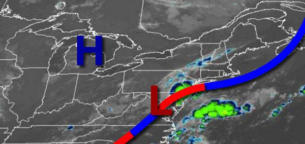
A stationary front and waves of weak low-pressure systems will keep an onshore wind and pesky showers over the region through this weekend. While a washout isn't expected, an umbrella would be a handy tool to keep around.
A wave of low pressure will move through the region today with scattered to broken clouds and isolated to widely scattered showers and thunderstorms through this afternoon. The bulk of the rainfall will be over southern New Jersey through this morning. Winds will veer to the northeast at 5 to 10 mph. Temperatures will rise into the upper 70s to lower 80s for highs this afternoon.
The stationary front will linger over the region tonight on through Saturday with scattered to broken cloud cover and isolated to widely scattered showers. Winds will be from the northeast at 5 to 15 mph. Temperatures tomorrow will range from the upper 60s to lower 70s for lows and mid to upper 70s for highs. Temperatures on Saturday will range from the mid to upper 60s for lows and upper 70s to lower 80s for highs.
High pressure will build into the region on Sunday with clear skies to scattered cloud cover after an isolated shower in the morning. Temperatures on Sunday will range from the upper 60s to lower 70s for lows and lower to mid-80s on the coast and mid to upper 80s elsewhere for highs.
A series of weak troughs and cold fronts will follow Monday on through Wednesday with scattered clouds and isolated to widely scattered showers. Temperatures through the period will range from the upper 60s to mid-70s for lows and lower to mid-80s along the coast and mid to upper 80s elsewhere for highs.
For details on your location, please visit the Local Seven Day Forecast!