A wet weather pattern will remain over the region through the weekend which will keep the threat for flash flooding in the forecast, especially for the Philadelphia metro and southern New Jersey.
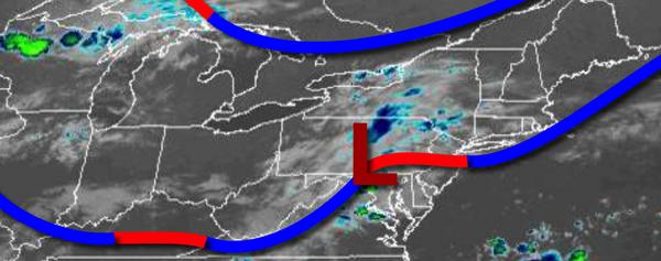
A cold front will slowly sink south today with waves of showers and thunderstorms expected to redevelop late this morning through this evening. The heaviest rainfall is expected to be over the Philadelphia metropolitan area and southern New Jersey with up to 4" of rain possible. However, isolated thunderstorms throughout the region will be capable of intense downpours, frequent lightning, and wind gusts over 40 mph at times. Winds will
back from the southeast to the northeast at 5 to 10 mph as the cold front sinks south. Temperatures will rise into the upper 70s to lower 80s for highs.
The cold front will stall to the south of the region tonight on through Saturday with scattered to broken cloud cover, drizzle, and isolated showers. Winds will be from the east at 5 to 15 mph. Temperatures tomorrow will range from the lower to mid-70s for lows and lower to mid-80s for highs. Temperatures on Saturday will range from the upper 60s to lower 70s for lows and upper 70s to lower 80s for highs.
An area of low pressure will pass through the region with periods of showers, heavy at times, throughout much of the region on Sunday. Temperatures will range from the mid to upper 60s for lows and mid to upper 70s for highs.
A warm front will follow on Monday with isolated to widely scattered showers and thunderstorms. Temperatures on Monday will range from the mid to upper 60s for lows and mid to upper 70s for highs.
A cold front will follow on Tuesday with showers and thunderstorms in the morning followed by clearing skies in the afternoon. Temperatures will range from the mid to upper 60s for lows and upper 70s to mid-80s for highs.
High pressure from the Canadian Maritimes will produce scattered to broken cloud cover on Wednesday and Thursday. An isolated shower is possible. Temperatures through the period will range from the mid to upper 60s for lows and upper 70s to mid-80s for highs.
For details on your location, please visit the Local Seven Day Forecast.