Pleasant weather conditions will continue through tomorrow, but a more tropical air mass is set to return for next week.
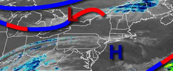
High pressure will slowly exit the region today on through tomorrow with scattered cloud cover expected. Winds will be from the southwest at around 5 mph. Temperatures will rise into the upper 70s to lower 80s for highs this afternoon. Temperatures tomorrow will range from the upper 50s to lower 60s over the interior and mid to upper 60s along the coast for lows and upper 70s to lower 80s for highs.
A warm front will lift through the region on Sunday with isolated to widely scattered showers and thunderstorms. The thunderstorms will be capable of brief heavy downpours, occasional lightning strikes, and wind gusts over 40 mph. Winds will be from the southwest at 5 to 10 mph. Temperatures will range from the mid to upper 60s for lows and lower to mid-80s along the coast and mid to upper 80s elsewhere for highs with slightly more humid
weather conditions.
The frontal boundary will linger over or just north of the region Monday on through Thursday with areas of fog in the morning and scattered to broken clouds in the afternoon with isolated thunderstorms. The thunderstorms will be capable of tropical downpours, frequent lightning, and wind gusts over 40 mph. At times, severe thunderstorms are a threat. Humid conditions will be in place with temperatures ranging from the upper 60s to lower
70s for lows and mid-80s to lower 90s for highs.
A strong cold front will follow on Friday with scattered showers and thunderstorms. Temperatures on Friday will range from the mid to upper 70s for lows and lower to mid-80s for highs.
For details on your location, please visit the Local Seven Day Forecast!