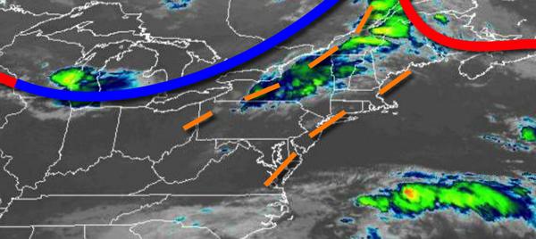
A strong cold front will bring the threat for isolated to widely scattered severe thunderstorms this afternoon while an active weather pattern continues through this week.
A strong cold front will move through the region today with widely scattered to isolated showers and strong to severe thunderstorms through this afternoon. The thunderstorms will be capable of intense downpours, small hail, frequent lightning, and wind gusts over 60 mph at times. Winds will veer from the southwest to the west at 5 to 15 mph. Temperatures will rise into the mid-80s to lower 90s for highs this
afternoon.
The cold front will drop south of the region tonight with clearing skies towards the morning. Winds will veer to the northwest at 5 to 10 mph. Temperatures will fall into the upper 50s to mid-60s for lows.
High pressure will build into the region tomorrow with clear skies to scattered cloud cover. Winds will be from the northwest at 5 to 10 mph. Temperatures will rise into the upper 70s to lower 80s for highs.
A warm front will follow on Thursday with scattered to broken clouds and isolated showers and thunderstorms. Winds will veer to the southwest at 5 to 15 mph. Temperatures on Thursday will range from the upper 50s to mid-60s for lows and upper 80s to mid-90s for highs.
A cold front will slowly approach on Friday with areas of fog in the morning followed by scattered clouds and isolated thunderstorms in the afternoon and evening. Temperatures on Friday will range from the lower to mid-70s for lows and mid-80s to lower 90s for highs.
The cold front will drop south while the remnants of Laura passes to the south with periods of rain in the afternoon and evening hours on Saturday. Temperatures on Saturday will range from the lower to mid-70s for lows and mid-80s to lower 90s for highs.
The cold front will clear the region on Sunday morning with lingering showers followed by clearing skies. Temperatures on Sunday will range from the upper 60s to lower 70s for lows and upper 70s to lower 80s for highs.
High pressure will be in control on Monday and Tuesday with clear skies to scattered cloud cover. Temperatures on Monday will range from the upper 40s to lower 50s ove the interior and mid to upper 50s along the coast for lows and mid to upper 70s for highs. Temperatures on Tuesday will range from the mid to upper 50s over the interior and lower to mid-6os along the coast for lows and mid-70s to lower 80s for highs.
For details on your location, please visit the Local Seven Day Forecast.