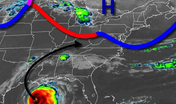
Excellent weather can be expected today, but an unsettled weather pattern returns by tomorrow with a threat for showers and thunderstorms in the afternoons followed by the remnants of Laura by Saturday night.
High pressure will produce clear skies to scattered cloud cover today. Winds will be from the northwest at 5 to 10 mph. Temperatures will rise into the mid-70s to lower 80s for highs this afternoon.
High pressure will exit off the coast tonight with clear skies to scattered cloud cover. Winds will back to the southwest at 5 to 15 mph. Temperatures tomorrow will fall into the lower to mid-60s for lows.
A warm front will lift through the region tomorrow with isolated showers and thunderstorms. Winds will be from the southwest at 10 to 20 mph. Temperatures will rise into the upper 70s to mid-80s over the northern interior and upper 80s to lower 90s elsewhere for highs with rising humidity.
The warm front will stall north of the region tomorrow night through Friday with fog in the morning followed by isolated showers and thunderstorms in the afternoon. Winds will be from the southwest at 5 to 15 mph. Temperatures on Friday will range from the lower to mid-70s for lows and mid-80s to lower 90s for highs.
A cold front will approach on Saturday with areas of fog in the morning and scattered to broken clouds in the afternoon with isolated thunderstorms. Temperatures on Saturday will range from the lower to mid-70s for lows and mid-80s to lower 90s for highs.
The cold front along with the remnants of Laura will move through the region Saturday night on through Sunday morning with periods of moderate to heavy rainfall. The heaviest rainfall is expected to be found over the Philadelphia metro, central New Jersey, and southern New Jersey with over 1" of rain possible. Temperatures will fall into the upper 60s to lower 70s for lows on Sunday morning.
Skies will clear on Sunday as the cold front clears the coast. Temperatures will rise into the upper 70s to lower 80s for highs.
High pressure will be in control on Monday and Tuesday with clear skies to scattered cloud cover. Temperatures on Monday will range from the mid-50s to lower 60s for lows and mid to upper 70s for highs. Temperatures on Tuesday will range from the upper 50s to mid-60s for lows and mid-70s to lower 80s for highs.
A warm front will approach on Wednesday with isolated showers in the afternoon and evening. Temperatures on Wednesday will range from the mid to upper 60s for lows and upper 70s to mid-80s for highs.
For details on your location, please visit the Local Seven Day Forecast.