Strong to severe thunderstorms are a threat again this afternoon as the active weather pattern continues through this weekend.
A warm front will continue to lift north through the region today with scattered showers and strong to severe thunderstorms. The best potential for severe thunderstorms this afternoon will be found over the northern interior on through the New York City metropolitan area with thunderstorms capable of intense downpours, vivid frequent lightning, hail, wind gusts over 60 mph, and isolated tornadoes. Winds will be from the southwest at 10 to 20
mph. Temperatures will rise into the mid-80s to lower 90s for highs this afternoon.
The warm front will stall to the north of the region tonight with areas of low clouds and fog along with isolated showers and thunderstorms. Winds will veer to the west at 5 to 15 mph. Temperatures will fall into the lower to mid-70s for lows.
The frontal boundary will sink south as a cold front tomorrow with isolated to widely scattered showers and thunderstorms. Winds will be from the west at 5 to 15 mph. Temperatures will rise into the mid-80s to lower 90s for highs in the afternoon.
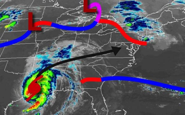
A strong cold front along with the remnants of Laura will follow on Saturday with periods of heavy rainfall and embedded thunderstorms. Winds will be from the southwest at 10 to 20 mph. Temperatures on Saturday will range from the lower to mid-70s for lows and lower to mid-80s for highs.
Strong Polar high pressure will be in control Sunday and Monday with clear skies to scattered cloud cover. Temperatures on Sunday will range from the mid-50s to lower 60s for lows and mid to upper 70s for highs. Temperatures on Monday will range from the upper 50s to lower 60s for lows and mid to upper 70s for highs.
A warm front will slowly approach the region Tuesday through Thursday with isolated to widely scattered showers and thunderstorms. Temperatures on Tuesday will range from the mid-60s for lows and lower to mid-70s for highs. Temperatures on Wednesday will range from the upper 60s to lower 70s for lows and mid-70s to lower 80s for highs. Temperatures on Thursday will range from the lower to mid-70s for lows and mid-80s to lower 90s for
highs.
For details on your location, please visit the Local Seven Day Forecast!