Waves of showers and thunderstorms will continue to be a threat through tomorrow as the remnants of Larua moves through the region.
A tropical air mass will remain in place today with areas of low clouds and morning fog giving way to hazy skies and scattered cloud cover along with widely scattered to scattered showers and strong to severe thunderstorms. The thunderstorms will be capable of torrential downpours, frequent lightning, and wind gusts over 60 mph. Winds will be from the southwest at 5 to 15 mph. Temperatures will rise into the mid-80s to lower 90s for
highs today.
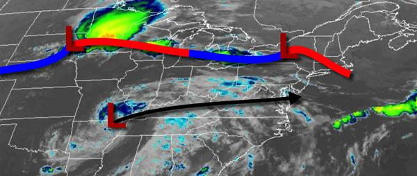
A cold front and the remnants of Laura will move through the region tomorrow with waves of heavy rainfall and strong to severe thunderstorms. Rainfall amounts of 0.50" to 1.50" are expected with locally higher amounts possible. Winds will be from the southwest at 5 to 15 mph. Temperatures tomorrow will range from the upper 60s to lower 70s for lows and upper 70s to mid-80s for highs.
Canadian high pressure will build into the region tomorrow night on through Sunday with clearing skies. Winds will veer to the northwest at 5 to 15 mph. Temperatures on Sunday will range from the upper 50s to mid-60s for lows and mid to upper 70s for highs.
High pressure will pass over the region on Monday with clear skies to scattered cloud cover. Temperatures on Monday will range from the upper 40s to mid-50s over the interior and mid to upper 50s along the coast for lows and upper 60s to mid-70s over the interior and mid to upper 70s along the coast.
A warm front will approach the region on Tuesday and Wednesday with waves of showers and thunderstorms. Temperatuers on Tuesday will range from the lower to mid-60s for lows and upper 60s to lower 70s for highs. Temperatures on Wednesday will range from the mid to upper 60s for lows and upper 70s to mid-80s for highs.
The warm front will lift north of the region on Thursday with areas of fog in the morning followed by isolated thunderstorms in the afternoon. Temperatures on Thursday will range from the lower to mid-70s for lows and mid-80s to lower 90s for highs.
A cold front will clear the region on Friday morning with isolated showers followed by clearing skies. Temperatures on Friday will range from the lower to mid-70s for lows and mid-80s to lower 90s for highs.
For details on your location, please visit the Local Seven Day Forecast.