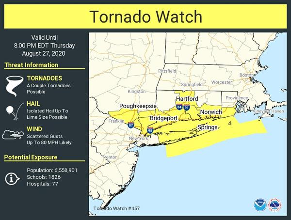
 Tornado Watch Number 457
   NWS Storm Prediction Center Norman OK
   315 PM EDT Thu Aug 27 2020

   The NWS Storm Prediction Center has issued a

   * Tornado Watch for portions of
     Connecticut
     Southeast New York and Long Island
     Southern Rhode Island
     Coastal Waters

   * Effective this Thursday afternoon and evening from 315 PM until
     800 PM EDT.

   * Primary threats include...
     A couple tornadoes possible
     Scattered damaging winds likely with isolated significant gusts
       to 80 mph possible
     Isolated very large hail events to 2 inches in diameter possible

   SUMMARY...Cluster of embedded supercells will spread from the Lower
   Hudson Valley across southwest New England with a risk for all
   severe hazards.

   The tornado watch area is approximately along and 40 statute miles
   north and south of a line from 20 miles southwest of Poughkeepsie NY
   to 30 miles southeast of Block Island RI. For a complete depiction
   of the watch see the associated watch outline update (WOUS64 KWNS
   WOU7).