A series of cold fronts will keep the threat of showers and thunderstorms through tomorrow morning. Excellent weather follows for the rest of the holiday weekend.
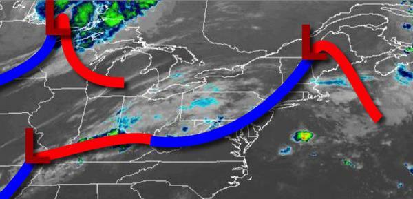
A cold front will stall over the region today with widely scattered to scattered showers and strong to severe thunderstorms. The best potential for severe thunderstorms will be over southeastern Pennsylvania and southern New Jersey. The thunderstorms will be capable of intense downpours, frequent lightning, hail, and wind gusts over 60 mph. Winds will be from the southwest at 5 to 15 mph. Temperatures will rise into the lower to
mid-80s for highs.
A stronger cold front will follow tonight on through tomorrow morning with isolated to widely scattered showers and thunderstorms. Winds will veer from the southwest to west at 5 to 10 mph. Temperatures will fall into the mid-60s to lower 70s for lows.
The cold front will clear the coast tomorrow afternoon with clearing skies. Winds will veer to the northwest at 5 to 15 mph. Temperatures will rise into the lower to mid-80s for highs with falling humidity.
High pressure will be in control tomorrow night on through Labor Day Monday with clear skies to scattered cloud cover. Winds will be light and variable. Temperatures on Saturday will range from the upper 50s to mid-60s for lows and mid to upper 70s for highs. Temperatures on Sunday will range from the upper 50s to mid-60s for lows and mid-70s to lower 80s for highs. Temperatures on Labor Day Monday will range from the lower to
mid-60s for lows and mid-70s to lower 80s for highs.
A series of weak troughs will linger over the region on Tuesday through Thursday with scattered clouds and isolated showers. Temperatures on Tuesday will range from the lower to mid-60s for lows and mid-70s to lower 80s for highs. Temperatures on Wednesday will range from the lower to mid-60s for lows and upper 70s to mid-80s for highs. Temperatures on Thursday will range from the upper 60s to lower 70s for lows and mid to upper 80s for
highs.
For details on your location, please visit the Local Seven Day Forecast.