After the cold front exits, perfect weather will set in for the Labor Day Weekend.
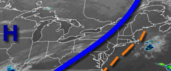
A cold front will clear the region this morning with isolated showers followed by clearing skies in the afternoon. Winds will veer to the west at 5 to 15 mph. Temperatures will rise into the lower to mid-80s for highs.
High pressure will build into the region tonight through tomorrow with clear skies to scattered cloud cover. Winds will be from the northwest at 5 to 15 mph. Temperatures tomorrow will range from the upper 50s to mid-60s for lows and mid to upper 70s for highs.
High pressure will pass over the region tomorrow night through Sunday with clear skies to scattered clouds. Winds will back to the southwest at 5 to 15 mph. Temperatures on Sunday will range from the upper 50s to lower 60s for lows and upper 70s to lower 80s for highs.
High pressure will exit on Monday with increasing clouds. Temperatures on Monday will range from the upper 50s to mid-60s for lows and mid-70s to lower 80s for highs.
A weak trough will develop over the region with broken clouds and isolated showers on Tuesday. Temperatures on Tuesday will range from the upper 60s to lower 70s for lows and upper 70s to mid-80s for highs.
A cold front will slowly approach the region Wednesday through Thursday with waves of showers and thunderstorms. Temperatures on Wednesday will range from the upper 60s to lower 70s for lows and mid-70s for highs. Temperatures on Thursday will range from the lower 70s for lows and mid to upper 70s for highs.
The cold front will exit on Friday with isolated showers in the morning followed by clearing skies in the afternoon. Temperatures on Friday will range from the mid-50s to lower 60s for lows and mid-60s to lower 70s for highs.
For details on your location, please visit the Local Seven Day Forecast.