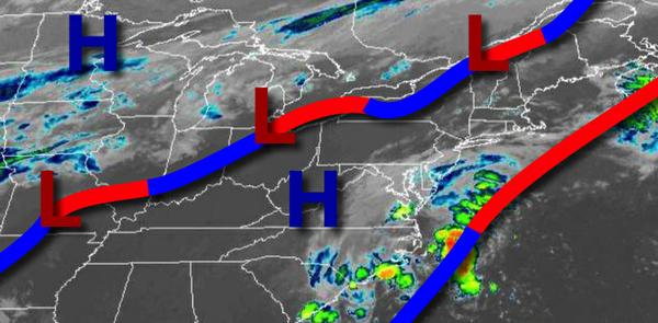
A warm front approaching from the Atlantic Ocean and a cold front from the eastern Great Lakes will bring the threat of heavy rainfall to the region by tomorrow morning.
A warm front will approach the region from the Atlantic Ocean today with increasing clouds and isolated showers developing towards evening. Winds will be from the east at 5 to 15 mph. Temperatures will rise into the upper 70s to lower 80s for highs this afternoon.
The warm front will press into the coast tonight on through tomorrow morning with showers increasing in coverage throughout the region. The bulk of the showers will be found along the coast with brief heavy downpours possible. Winds will veer from the east to southeast at 5 to 15 mph. Temperatures will fall into the upper 60s to lower 70s for lows.
A cold front will approach the region tomorrow afternoon with widespread showers and isolated to widely scattered thunderstorms capable of very heavy downpours and occasional lightning. Localized flash flooding will be a threat with rainfall amounts of 0.25" to 1.50" expected and localized amounts over 2.00" possible. The winds will veer from the southeast to northwest at 5 to 15 mph. Temperatures tomorrow will rise into the mid to upper
70s for highs.
The cold front will slowly clear the coast on Friday with morning showers giving way to clearing skies from northwest to southeast. Winds will veer from the northwest to the northeast at 5 to1 5 mph. Temperatures on Friday will range from the mid to upper 60s for lows and lower to mid-70s for highs.
High pressure over the Gulf of Maine will produce scattered to broken cloud cover but dry conditions on Saturday. Temperatures will range from the upper 50s to lower 60s for lows and upper 60s to lower 70s for highs.
A warm front will lift through the region on Sunday with scattered showers. Temperatures on Sunday will range from the mid-60s for lows and mid-70s to lower 80s for highs.
A cold front will follow Sunday night into Monday morning with scattered showers followed by clearing skies by Monday afternoon. Temperatures on Monday will range from the upper 60s to lower 70s for lows and upper 70s to lower 80s for highs.
High pressure will be in control Tuesday and Wednesday with clear skies to scattered cloud cover. Temperatures on Tuesday will range from the mid-50s to lower 60s for lows and upper 60s to lower 70s for highs. Temperatures on Wednesday will range from the mid-40s to lower 50s over the interior and lower to mid-50s along the coast for lows and mid-60s to lower 70s for highs.
For details on your location, please visit the Local Seven Day Forecast!