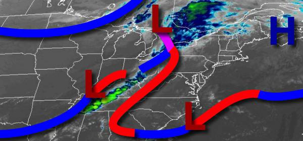
A series of frontal boundaries will lift through the region through tonight with a threat for showers, but tranquil weather conditions will return quickly.
A warm front will lift through the region today with isolated to widely scattered showers in the afternoon and evening. Winds will veer from the southeast to southwest at 5 to 15 mph. Temperatures will rise into the mid to upper 70s for highs.
A cold front will follow tonight through early tomorrow morning with isolated to widely scattered showers. Winds will veer from the southwest to northwest at 5 to 15 mph. Temperatures tomorrow will fall into the mid to upper 60s for lows.
High pressure will build into the region tomorrow with clear skies to scattered cloud cover. Winds will be from the northwest at 5 to 15 mph. Temperatures tomorrow will rise into the mid to upper 70s for highs.
High pressure will pass to the north of the region on Tuesday with clear skies to scattered cloud cover. Winds will veer to the northeast at 5 to 15 mph. Temperatures on Tuesday will range from the upper 40s to mid-50s for lows and mid-60s to lower 70s for highs.
High pressure will remain in control Wednesday and Thursday with clear skies to scattered cloud cover. Temperatures on Wednesday will range from the lower to mid-50s for lows and upper 60s to mid-70s for highs. Temperatures on Thursday will range from the upper 40s to mid-50s over the interior and upper 50s to mid-60s along the coast for lows and mid-70s to lower 80s for highs.
A cold front will pass through the region with periods of showers and isolated thunderstorms on Friday. Temperatures on Friday will range from the lower to mid-60s for lows and mid to upper 60s for highs.
High pressure will be in control on Saturday and Sunday with clear skies to scattered cloud cover. Temperatures on Saturday will range from the mid-40s to lower 50s for lows and upper 50s to lower 60s for highs. Temperatures on Sunday will range from the upper 30s to lower 40s over the interior and mid-40s to lower 50s along the coast and mid-50s to lower 60s over the interior and lower to mid-60s along the coast for highs.
For details on your location, please visit the Local Seven Day Forecast.