Waves of heavy rainfall and strong winds are on the way for tonight on through tomorrow morning with the threat of flash flooding, wind damage, and potential power outages.
A cold front will slowly approach the region today with increasing clouds and widely scattered to scattered showers by this afternoon. Winds will be from the south at 10 to 20 mph. Temperatures will rise into the lower to mid-70s for highs.
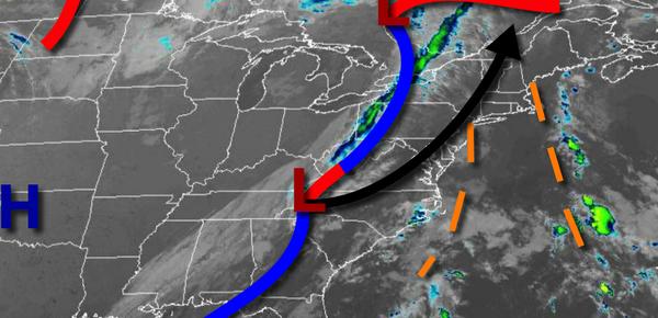
An area of low pressure and the cold front will lift through the region tonight on through tomorrow with waves of moderate to heavy rainfall. Rainfall amounts will range from 1" to 3" on the New Jersey coast, New York City metropolitan area, Long Island, and Connecticut, 1" to 2" throughout the Delaware River Valley, Hudson River Valley, and the Catskills, and 0.50" to 1" over the rest of eastern Pennsylvania including the Poconos. Winds will
be from the south at 15 to 30 mph with gusts over 40 mph along the coast and Long Island and 10 to 20 mph with gusts over 30 mph elsewhere. Temperatures will fall into the upper 50s to lower 60s for lows.
The cold front will clear the coast tomorrow morning with clearing skies tomorrow afternoon and evening. Winds will veer to the west at 5 to 15 mph. Temperatures tomorrow will rise into the upper 60s to lower 70s for highs.
A weak cold front will follow on Thursday with isolated showers. Winds will be from the west at 5 to 15 mph. Temperatures on Thursday will range from the mid-50s to lower 60s for lows and upper 60s to lower 70s for highs.
Another cold front will follow on Friday with scattered showers expected. Temperatures on Friday will range from the mid-50s to lower 60s for lows and lower to mid-60s over the interior and mid to upper 60s along the coast for highs.
High pressure will be in control on Saturday and Sunday with clear skies to scattered cloud cover. Temperatures on Saturday and Sunday will range from the mid-30s to lower 40s over the interior and mid-40s to lower 50s along the coast for lows and mid to upper 60s for highs.
An area of low pressure will produce waves of moderate to heavy rainfall on Monday. Temperatures on Monday will range from the mid to upper 50s for lows and lower to mid-60s for highs.
High pressure will produce clear skies to scattered cloud cover on Tuesday. Temperatures on Tuesday will range from the lower to mid-50s for lows and mid to upper 60s for highs.
For details for your location, please visit the Local Seven Day Forecast!