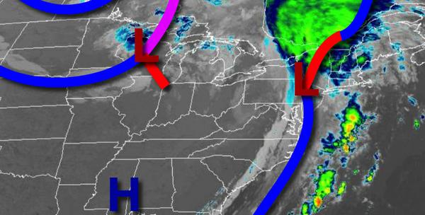
After waves of rainfall this morning, a cool Fall weather pattern will return but another heavy rainstorm looms by early next week.
Waves of heavy rain this morning will exit after 9 AM with clearing skies in the afternoon and evening. Winds will be from the west at 5 to 15 mph. Temperatures will rise into the upper 60s to lower 70s for highs.
A weak cold front will follow tomorrow with a few isolated showers in the afternoon and evening. Winds will be from the west at 5 to 15 mph. Temperatures tomorrow will range from the mid-50s to lower 60s for lows and upper 60s to lower 70s for highs.
Another cold front will follow on Friday morning with scattered showers capable of brief heavy downpours followed by clearing skies in the afternoon and evening. Winds will veer to the northwest at 5 to 15 mph. Temperatures on Friday will range from the mid-60s to lower 60s for lows and lower to mid-60s for highs.
High pressure will be in control Saturday and Sunday with clear skies and light winds. Temperatures through the weekend will range from the mid-30s to lower 40s over the interior and mid-40s to lower 50s along the coast for lows and upper 50s to lower 60s over the interior and lower to mid-60s along the coast for highs.
An area of low pressure will bring heavy rain and strong winds on Monday. Areas of flash flooding, poor visibility, and minor wind damage will be a threat. Temperatures on Monday will range from the mid to upper 50s for lows and lower to mid-60s for highs.
High pressure will be in control on Tuesday and Wednesday with clear skies to scattered cloud cover. Temperatures on Tuesday will range from the upper 40s to lower 50s for lows and lower to mid-60s for highs. Temperatures on Wednesday will range from the upper 30s to mid-40s over the interior and upper 40s to lower 50s along the coast for lows and mid-60s for highs.
For details on your location, please visit the Local Seven Day Forecast!