High pressure will produce tranquil weather today but another rainstorm is expected to return by Friday afternoon.
High pressure will pass over the region today on through tomorrow with clear skies to scattered cloud cover. Winds will back from the west to southwest at 5 to 15 mph. Temperatures will rise into the mid to upper 60s for highs today. Temperatures tomorrow will range from the lower to mid-50s for lows and upper 60s to mid-70s for highs.
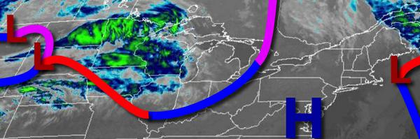
A cold front will approach the region on Friday with increasing clouds in the morning and showers developing in the afternoon. A wave of low pressure will develop along the cold front which will produce waves of moderate to heavy rainfall on Friday evening through early Saturday morning. Rainfall amounts of around 1 to 2 inches can be expected along the coast and around a half an inch over the interior. Winds will veer from the southwest
to north at 10 to 20 mph. Temperatures on Friday will range from the upper 50s to mid-60s for lows and mid-60s to lower 70s for highs.
Showers will linger on Saturday morning followed by clearing skies and breezy conditions. Temperatures on Saturday will range from the mid to upper 40s for lows and mid to upper 50s for highs.
High pressure will produce clear skies to scattered cloud cover Sunday on through Wednesday with clear skies to scattered cloud cover. Temperatures on Sunday will range from the upper 30s to mid-40s for lows and lower to mid-60s for highs. Temperatures on Monday will range from the upper 30s to mid-40s for lows and mid-60s to lower 70s for highs. Temperatures on Tuesday will range from the mid-50s to lower 60s for lows and upper 60s to
mid-70s for highs. Temperatures on Wednesday will range from the lower to mid-60s for lows and upper 60s to mid-70s for highs.
For details on your location, please visit the Local Seven Day Forecast.