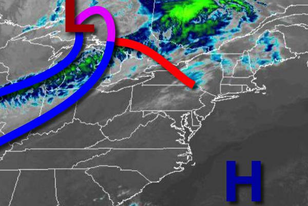
Clouds will be on the increasing today as a cold front approaches with a heavy rain threat for tomorrow evening.
High pressure will exit today with increasing clouds through this evening. Winds will be from the southwest at 5 to 15 mph with gusts over 20 mph at times. Temperatures will rise into the upper 60s to mid-70s for highs this afternoon.
A cold front will move through the region tonight through tomorrow morning with cloudy skies and a few isolated showers. A wave of low pressure will develop along the cold front and track over the coastal waters with waves of rainfall in the afternoon and continue on through tomorrow night. The heaviest rainfall will be focused along the coast with one to two inches of rain while interior locations can expect around 0.25" of rain. Winds
will back to the northwest at 10 to 20 mph. Temperatures tomorrow will range from the mid to upper 50s for lows and upper 50s to mid-60s for highs.
The low-pressure system will exit on Saturday morning with lingering showers followed by clearing skies for the rest of the day. Winds will be from the northwest at 10 to 20 mph. Temperatures on Saturday will range from the mid-30s to lower 40s over the interior and mid to upper 40s along the coast for lows and upper 50s for highs.
High pressure will be in control Sunday on through Thursday with clear skies to scattered cloud cover expected. Temperatures on Sunday will range from the upper 30s to mid-40s for lows and lower to mid-60s for highs. Temperatures on Monday will range from the mid-40s to lower 50s for lows and mid to upper 60s for highs. Temperatures on Tuesday will range from the upper 40s to mid-50s for lows and upper 60s to lower 70s for highs.
Temperatures on Wednesday will range from the lower to mid-50s for lows and upper 60 to lower 70s for highs. Temperatures on Thursday will range from the mid to upper 50s for lows and mid to upper 70s for highs.
For details on your location, please visit the Local Seven Day Forecast!