Locally dense fog has returned this morning and has reduced visibility below a mile in many locations. The fog threat will be an issue once again tomorrow morning as well.
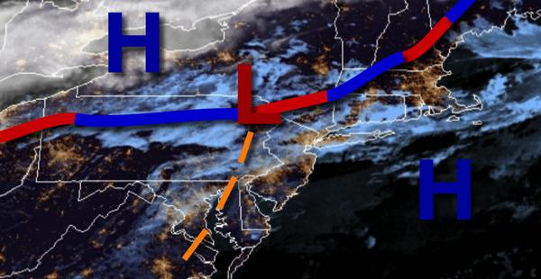
A stationary front to the north of the region will continue to linger with locally dense fog in the morning giving way to scattered to broken clouds and isolated showers in the afternoon. Winds will be from the southeast at 5 to 15 mph. Temperatures will rise into the upper 60s to lower 70s for highs.
The stationary front will drift northward tonight through tomorrow with locally dense fog in the morning followed giving way to scattered to broken clouds and isolated showers in the afternoon. Winds will be from the southeast at 5 to 15 mph. Temperatures tomorrow will range from the upper 50s to lower 60s for lows and mid to upper 60s for highs.
A cold front will follow on Saturday with areas of fog in the morning followed by scattered to broken clouds and isolated showers in the afternoon. Skies will clear towards the evening. Winds will veer to the northwest at 5 to 15 mph. Temperatures on Saturday will range from the mid to upper 50s for lows and upper 60s to lower 70s for highs.
High pressure will be in control on Sunday with clear skies to scattered cloud cover. Temperatures on Sunday will range from the lower to mid-40s for lows and mid-50s for highs.
A warm front will follow on Monday with increasing clouds and widely scattered showers. Temperatures on Monday will range from the lower to mid-50s for lows and mid-60s to lower 70s for highs.
A series of cold fronts will follow on Tuesday and Wednesday with additional scattered showers. Temperatures on Tuesday will range from the lower to mid-50s for lows and mid to upper 50s for highs. Temperatures on Wednesday will range from the mid to upper 50s for lows and mid to upper 60s for highs.
High pressure will be in control on Thursday with clear skies to scattered clouds. Temperatures on Thursday will range from the mid-40s to lower 50s for lows and lower to mid-50s for highs.
For details on your location, please visit the Local Seven Day Forecast.