Dry yet chilly weather conditions will be in place for this Halloween, but a strong cold front follows with heavy rainfall a threat tomorrow afternoon.
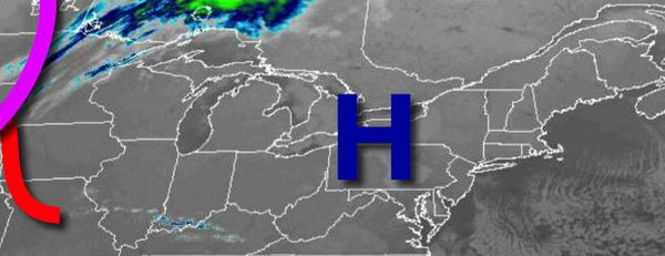
High pressure this Halloween will produce clear skies to scattered clouds. Winds will be light and variable. Temperatures will rise into the mid-40s for highs.
High pressure will exit tonight with clear skies to scattered clouds with winds developing from the west at 5 to 10 mph. Temperatures will fall into the upper 30s to mid-40s for lows.
A strong cold front will move through the region in the afternoon and evening with periods of showers capable of heavy downpours at times. Winds will be from the southwest at 10 to 20 mph with gusts over 25 mph at times. Temperatures tomorrow will rise into the upper 50s to lower 60s for highs.
High pressure will produce clear skies to scattered clouds on Monday. Winds will veer to the northwest at 15 to 25 mph with gusts over 30 mph at times. Temperatures on Monday will range from the mid to upper 30s for lows and lower to mid-40s for highs.
High pressure will produce clear skies to scattered clouds from Tuesday on through Saturday. Temperatures will steadily moderate to above normal levels through the forecast period. Temperatures on Tuesday will range from the upper 30s to lower 40s for lows and upper 40s to lower 50s for highs. Temperatures on Wednesday will range from the mid-30s to lower 40s for lows and mid-50s to lower 60s for highs. Temperatures on Thursday
will range from the mid-40s to lower 50s for lows and upper 50s to mid-60s for highs. Temperatures on Friday will range from the lower to mid-50s for lows and mid to upper 60s for highs. Temperatures on Saturday will range from the upper 40s to mid-50s for lows and mid-60s to lower 70s for highs.
For details on your location, please visit the Local Seven Day Forecast.