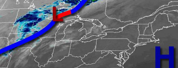
After the fog lifts, tranquil and warm conditions will continue, but a cold front will bring periods of rain to the region by tomorrow afternoon. A colder and active weather pattern returns by next week.
High pressure will exit today with morning fog giving way to increasing clouds in the afternoon and evening. Winds will be from the southwest at 5 to 15 mph. Temperatures will rise into the mid-60s to lower 70s for highs this afternoon.
A cold front will approach tonight through tomorrow morning with broken to overcast clouds. Winds will be from the southwest at 5 to 15 mph. Temperatures will fall into the upper 50s to lower 60s for lows.
The cold front will begin to press into the region tomorrow afternoon and evening with periods of rain, heavy at times. Winds will be from the southwest at 5 to 15 mph. Temperatures tomorrow will rise into the mid-60s to lower 70s for highs.
The cold front will slowly sink through the region on Thursday with periods of rain, heavy at times, especially in the morning. Winds will veer from the southwest to northwest at 5 to 15 mph. Temperatures on Thursday will range from the mid to upper 50s for lows and upper 50s to lower 60s for highs.
A weak trough will pass through the region on Friday with scattered clouds and isolated showers. Temperatures on Friday will range from the upper 40s to lower 50s for lows and upper 50s for highs.
High pressure will produce clear skies to scattered clouds on Saturday. Temperatures on Saturday will range from the lower to mid-40s for lows and upper 40s to mid-50s for highs.
An area of low pressure and the remnants of Eta will lift through the region on Sunday with periods of moderate to heavy rainfall. Temperatures on Sunday will range from the mid to upper 40s for lows and upper 50s to lower 60s for highs.
A series of cold fronts will follow on Monday and Tuesday with isolated to widely scattered rain and snow showers. Temperatures on Monday will range from the mid to upper 40s for lows and upper 50s for highs. Temperatures on Tuesday will range from the mid-30s to lower 40s for lows and upper 30s to mid-40s for highs.
For details on your location, please visit the Local Seven Day Forecast!