Excellent weather conditions will continue through tomorrow, but a slow cold front will bring waves of rainfall to the region by Wednesday night.
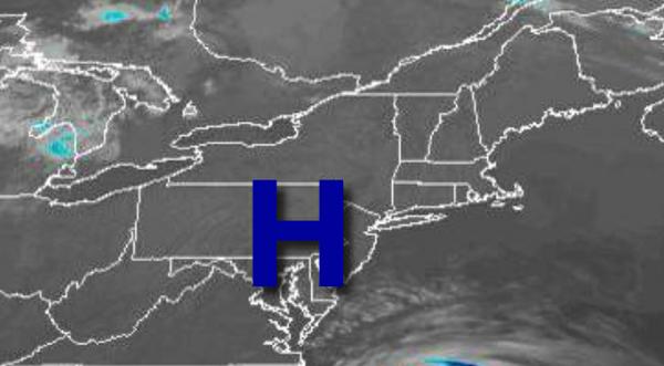
High pressure will move over the region today with clear skies to a few clouds. Winds will be from the southwest at 5 to 10 mph. Temperatures will rise into the upper 60s to lower 70s for highs this afternoon.
High pressure will exit tomorrow with increasing clouds expected. Winds will be from the southwest at 5 to 15 mph. Temperatures will range from the upper 40s to mid-50s for lows and mid-60s to lower 70s for highs.
A cold front will slowly approach the region on Wednesday with rain developing in the afternoon and evening hours, becoming heavy at times. Winds will back to the south at 5 to 15 mph. Temperatures on Wednesday will range from the upper 50s to lower 60s for lows and mid-60s to lower 70s for highs.
The cold front will slowly move through the region on Thursday with periods of rain, heavy at times. Some urban flooding will be a threat. Rainfall amounts of 1" to 3" can be expected throughout the region. Temperatures on Thursday will range from the upper 50s to mid-60s for lows and mid to upper 60s for highs.
The cold front will exit on Friday with showers in the morning followed by clearing skies in the afternoon and evening. Temperatures on Friday will lower to mid-50s for lows and mid-50s to lower 60s for highs.
High pressure will be in control on Saturday with scattered cloud cover. Temperatures on Saturday will range from the upper 30s to mid-40s for lows and upper 40s to lower 50s for highs.
Another area of low pressure will move through the region on Sunday and Monday with scattered showers expected. Temperatures on Sunday will range from the upper 30s to mid-40s for lows and upper 50s to lower 60s for highs. Temperatures on Monday will range from the mid to upper 50s for lows and upper 50s to lower 60s for highs.
For details on your location, please visit the Local Seven Day Forecast!