Pleasant weather conditions are coming to an end with waves of moderate to heavy rainfall this evening and colder weather on the way.
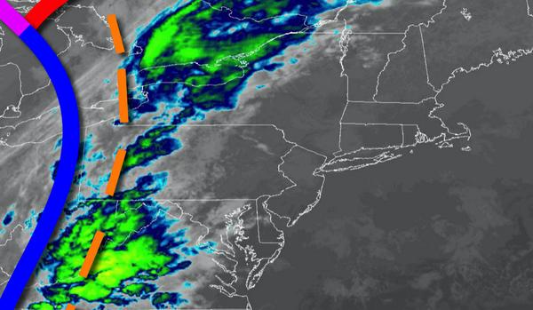
A cold front will approach the region with showers developing in the afternoon and evening, becoming heavy at times and widespread. Winds will be from the south at 5 to 15 mph. Temperatures will rise into the upper 60s to lower 70s for highs this afternoon.
The cold front will slowly move through the region tonight on through tomorrow with waves of rainfall, heavy at times through the afternoon. Rainfall amounts will range from 0.25" to 0.75" over the interior, 1" to 2" in the Philadelphia and New York City metropolitan areas, and 2" to 4" in the southern suburbs of Philadelphia and southern New Jersey. Winds will veer to the northwest at 5 to 15 mph. Temperatures tomorrow will range from
the upper 40s to mid-50s for lows and mid to upper 50s for highs.
A weak area of low pressure will pass off the coast on Friday with scattered to broken clouds and isolated showers. Winds will back to the northeast at 5 to 10 mph. Temperatures on Friday will range from the upper 40s to lower 50s for lows and lower to mid-50s for highs.
High pressure will be in control on Saturday with clear skies to scattered cloud cover. Temperatures on Saturday will range from the upper 30s to lower 40s for lows and upper 40s to lower 50s for highs.
A warm front will lift through the region on Sunday with scattered showers expected, heavy at times. Temperatures on Sunday will range from the mid to upper 40s for lows and upper 50s to lower 60s for highs.
A series of cold fronts will follow on Monday and Tuesday with isolated to widely scattered showers, mixing with snow at times over the Poconos and Catskills. Temperatures on Monday will range from the upper 40s to lower 50s for lows and mid-50s for highs. Temperatures on Tuesday will range from the lower to mid-30s over the interior and mid to upper 30s along the coast for lows and upper 30s to mid-40s for highs.
High pressure will produce clear skies to scattered cloud cover on Wednesday. Temperatures will range from the mid-20s to lower 30s for lows and mid-30s to lower 40s for highs.
For details on your location, please visit the Local Seven Day Forecast.