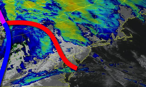
A strong cold front will bring heavy rain and strong winds this evening, marking a turn to a more volatile weather pattern.
A warm front will lift through the region this afternoon with increasing clouds and widely scattered showers. Winds will be from the south at 10 to 20 mph. Temperatures will rise into the upper 50s to lower 60s for highs.
A strong cold front will follow this evening through tomorrow morning with heavy rainfall and a few embedded thunderstorms from 6 PM to 10 PM from west to east. The thunderstorms will be capable of heavy downpours, occasional lightning, and wind gusts over 40 mph at times. Showers will linger through the early morning hours tomorrow. Winds will veer to the west at 10 to 20 mph with higher gusts. Temperatures will fall into the
lower to mid-40s for lows.
A series of troughs of low pressure will follow tomorrow with scattered to broken cloud cover and isolated to widely scattered showers. Winds will be from the west at 5 to 15 mph. Temperatures will rise into the upper 40s to lower 50s for highs.
A stronger cold front will follow on Tuesday with isolated to widely scattered rain and snow showers. Winds will be from the northwest at 5 to 15 mph. Temperatures will range from the mid to upper 30s for lows and upper 30s to mid-40s for highs.
High pressure will be in control on Wednesday and Thursday with clear skies to scattered clouds. Temperatures on Wednesday will range from the mid-20s to lower 30s for lows and mid to upper 30s for highs. Temperatures on Thursday will range from the mid to upper 20s for lows and mid-40s to lower 50s for highs.
A series of cold fronts and troughs of low pressure will pass through the region on Friday through Sunday with scattered to broken clouds and isolated showers. Temperatures will range from the mid-40s to lower 50s for lows and mid-50s to lower 60s for highs.