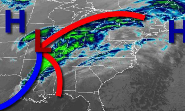
Clouds will be on the increase today as a storm approaches from the Mississippi River Valley with rain on the way for Thanksgiving morning.
Clouds will be increasing through this evening as high-pressure exits and a low-pressure system approaches from the southwest. Winds will be from the southwest at 5 to 15 mph. Temperatures this afternoon will rise into the mid-40s to lower 50s over the interior and mid to upper 50s along the coast for highs.
An area of low pressure will approach the region tonight with showers developing after midnight. Winds will be from the south at 5 to 15 mph. Temperatures will fall into the mid-40s to lower 50s over the interior and lower to mid-50s along the coast for lows.
Waves of rainfall, heavy at times, is expected tomorrow morning as the low-pressure system lifts through the region. Showers will linger in the afternoon followed by clearing skies in the evening. Winds will veer to the west at 5 to 15 mph. Temperatures will rise into the mid-50s to lower 60s for highs tomorrow afternoon.
High pressure will be in control tomorrow night through Friday with clear skies to scattered clouds. Winds will be from the west at 5 to 15 mph. Temperatures on Friday will range from the upper 30s to mid-40s over the interior and mid to upper 40s along the coast for lows and upper 40s to lower 50s over the interior and mid to upper 50s along the coast for highs.
High pressure will be in control Saturday and Sunday with clear skies to scattered cloud cover. Temperatures on Saturday will range from the upper 30s to mid-40s for lows and mid-40s to lower 50s for highs. Temperatures on Sunday will range from the upper 20s to lower 30s over the interior and mid to upper 30s along the coast for lows and mid-40s to lower 50s for highs.
An area of low pressure will produce periods of rain, heavy at times, on Monday afternoon through Tuesday. Temperatures on Monday will range from the upper 30s to lower 40s over the interior and mid to upper 40s along the coast for lows and mid-50s to lower 60s for highs. Temperatures on Tuesday will range from the upper 30s to mid-40s over the interior and upper 40s to lower 50s along the coast for lows and mid-40s to lower 50s over the
interior and mid to upper 50s along the coast for highs.
High pressure will be in control on Wednesday with clear skies to scattered clouds. Temperatures on Wednesday will range from the upper 20s to mid-30s over the interior and upper 30s to lower 40s along the coast for lows and mid-30s to lower 40s over the interior and mid to upper 40s along the coast for highs.