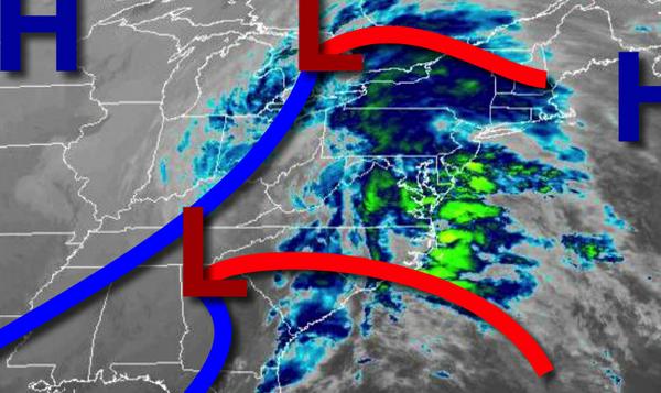
Heavy rain and strong winds this afternoon will kick start a chilly, active weather pattern through next weekend.
An area of low pressure and a warm front will lift through the region today with waves of moderate to heavy downpours and embedded thunderstorms from 8 AM to 6 PM from south to north. The embedded thunderstorms will be capable of wind gusts over 40 mph at times. Winds will veer from the southeast to south at 10 to 20 mph. Temperatures will rise into the upper 50s to lower 60s for highs.
The area of low pressure will lift into the eastern Great Lakes tonight through tomorrow with drizzle and isolated to widely scattered showers. Some snow will mix into the rainfall for the higher elevations. Winds will veer to the southwest at 10 to 20 mph. Temperatures will fall through the 50s, 40s, and 30s through the day.
A series of weak troughs will follow on Wednesday as the low-pressure system lifts into Canada with scattered to broken cloud cover and isolated to widely scattered rain and snow showers. Winds will be from the southwest at 5 to 15 mph. Temperatures on Wednesday will range from the upper 20s to mid-30s for lows and mid to upper 30s over the interior and lower to mid-40s along the coast for highs.
High pressure will produce clear skies to scattered cloud cover on Thursday with a few flurries possible over the Poconos. Temperatures on Thursday will range from the mid-20s to lower 30s over the interior and lower to mid-30s along the coast for lows and upper 30s to mid-40s for highs.
High pressure will exit on Friday with increasing clouds throughout the day. Temperatures on Friday will range from the upper 20s to mid-30s over the interior and upper 30s to lower 40s along the coast for lows and lower to mid-40s over the interior and mid-40s to lower 50s along the coast for highs.
An area of low pressure will develop over the coastal waters on Saturday and Sunday with scattered showers along the coast and scattered rain and snow showers over higher elevations. Temperatures on Saturday will range from the lower to mid-30s for lows and upper 30s to mid-40s for highs. Temperatures on Sunday will range from the upper 20s to mid-30s for lows and upper 30s to mid-40s for highs.
A weak trough will produce scattered clouds with a few isolated snow showers on Monday. Temperatures will range from the lower to mid-20s over the interior and upper 20s to mid-30s along the coast for lows and upper 20s to mid-30s over the interior and mid to upper 30s along the coast for highs.