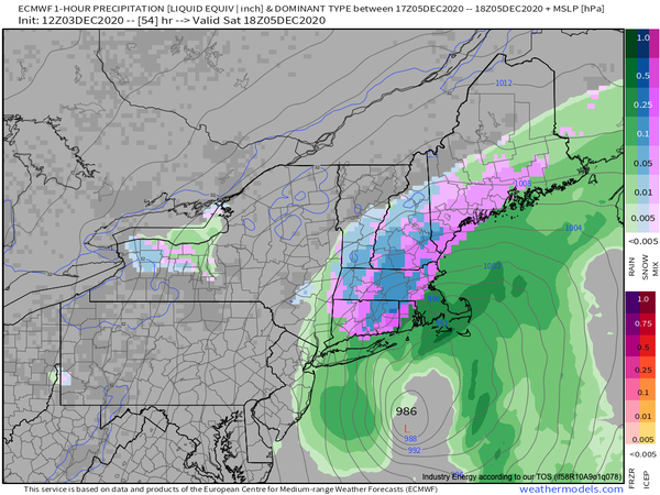
A complicated winter storm will bring waves of rainfall to the whole region by tomorrow evening, but as colder air works into the storm, snow will be a threat for interior locations, especially Connecticut.
The storm is currently organizing over the Southern Plains and will be lifting towards the Tennessee River Valley by tomorrow afternoon. A cold front will be dropping south through the Philadelphia and New York City metropolitan areas at the same time tomorrow afternoon with increasing cloud cover and isolated to widely scattered showers.
As the surface low-pressure system approaches the Delmarva Peninsula tomorrow evening, the rain will break out throughout the region and become heavy along the coast towards midnight. Colder air will start to push into the higher elevations of the Poconos and Catskills with some snow mixing in for elevations above 1,000 feet towards midnight.
On Saturday morning, the low-pressure system will intensify off the New Jersey coast and begin to track to the south of Long Island. Rainfall, heavy at times will continue throughout much of the region, however, snow will mix into the rain and begin to change over to all snow from the Poconos and Catskills and then sink to the southeast through the morning hours towards northwestern New Jersey before ending. Some minor snow accumulation is
expected, mostly on cold surfaces.
On Saturday afternoon, the storm will track from the coastal waters of Long Island towards the coastal waters of southeastern New England. The precipitation will end from west to east over the Philadelphia and New York City metropolitan areas from 9 AM to 1 PM with some snow possible at the end of the storm. Winds will be back to the northwest at 10 to 20 mph and temperatures will fall into the 30s. Meanwhile, the heavy rain over
Connecticut and Long Island will change over to snow from north to south through the afternoon hours, tapering off towards evening as the storm lifts towards the Gulf of Maine. Portions of northern and northeastern Connecticut will experience the longest duration of snow with the potential for accumulation on all surfaces.
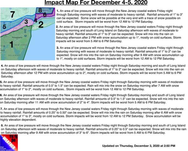
Details on the impact of this storm can be found below.