High pressure will build into the region this evening on through tomorrow with scattered cloud cover expected. Winds will be from the northwest at 5 to 15 mph. Temperatures tomorrow will range from the lower to mid-20s over the interior and upper 20s to lower 30s along the coast and upper 20s to lower 30s over the interior and mid to upper 30s along the coast.
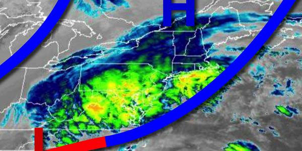
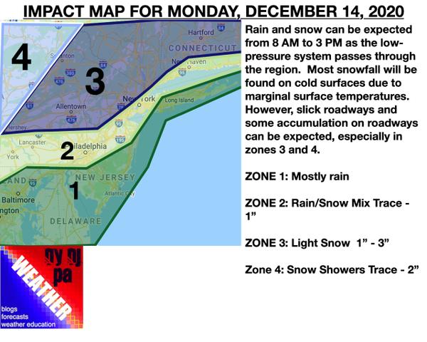
An area of low pressure will approach on Wednesday with increasing clouds through the morning followed by precipitation breaking out in the afternoon and evening. Periods of rain, mixing with snow at times can be expected for southern New Jersey, while a mix of snow, sleet, and rain can be expected for the Philadelphia metropolitan area, central New Jersey, and the New York City metropolitan area, finally, snow will develop for the northwestern
suburbs and northern interior. Winds will be from the north at 10 to 20 mph with gusts over 30 mph at times. Temperatures on Wednesday will range from the upper 10s to mid-20s for lows and mid to upper 20s over the interior, lower to mid-30s in the Philadelphia and New York City metropolitan areas, and upper 30s to mid-40s in southern New Jersey.
The area of low pressure will move through the coastal waters while intensifying on Wednesday night through Thursday morning with all precipitation changing over to heavy snow from northwest to southeast. Windy conditions can be expected along with poor travel conditions. The snow will exit in the afternoon. Temperatures will fall through the 40s, 30s, and 20s throughout the day.
High pressure will be in control on Friday through Monday with clear skies to scattered cloud cover. Temperatures on Friday and Saturday will range from the single digits to mid-10s over the interior and upper 10s to mid-20s along the coast for lows and mid-20s to lower 30s over the interior and lower to mid-30s along the coast for highs. Temperatures on Sunday will range from the mid to upper 20s for lows and mid-30s to lower 40s for highs.
Temperatures on Monday will range from the lower to mid-30s for lows and upper 30s to mid-40s for highs.