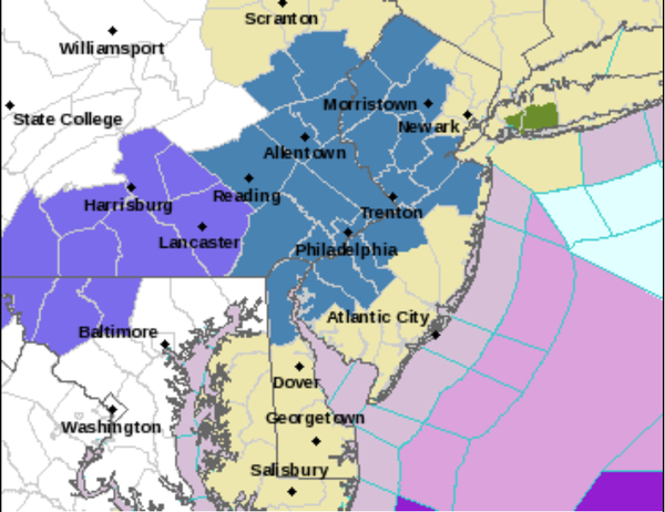
...WINTER STORM WATCH IN EFFECT FROM WEDNESDAY MORNING THROUGH
THURSDAY MORNING...

* WHAT...Heavy snow possible. Total snow accumulations of 12
  inches or more possible.

* WHERE...Portions of the Poconos, Lehigh Valley, and northwest
  New Jersey.

* WHEN...From Wednesday morning through Thursday morning.

* IMPACTS...Travel could be very difficult. The hazardous
  conditions could impact the morning or evening commute.

* ADDITIONAL DETAILS...Heavy snow could have the potential to
  cause power outages.
..WINTER STORM WATCH IN EFFECT FROM WEDNESDAY MORNING THROUGH
THURSDAY MORNING...

* WHAT...Heavy snow possible. Total snow accumulations of 5 or
  more inches possible. Winds could gust as high as 30 mph.

* WHERE...Portions of New Jersey, southeast Pennsylvania and
  northern Delaware along and near the I-95 corridor.

* WHEN...From Wednesday morning through Thursday morning.

* IMPACTS...Travel could be very difficult. The hazardous
  conditions could impact the morning or evening commute.

* ADDITIONAL DETAILS...Snow is anticipated to move into the region
  Wednesday morning and some areas in the watch may mix with sleet
  and rain. We anticipate there will likely be a sharp gradient in
  snow totals depending on precipitation type.