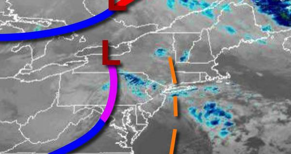
A pesky cold front will produce a few showers this morning. A much stronger cold front is expected for Thursday night that will produce a bumpy ride for Santa for Christmas Eve.
A weak trough and cold front will pass through the region with showers in the morning followed by clearing skies in the afternoon. Winds will be from the northwest at 5 to 15 mph. Temperatures will rise into the upper 30s to mid-40s for highs this afternoon.
High pressure will produce scattered clouds tonight on through tomorrow with winds backing to the southwest at 5 to 15 mph. Temperatures tomorrow will range from the mid-10s to lower 20s over the interior and mid-20s to lower 30s along the coast for lows and upper 30s to mid-40s for highs.
A cold front will approach on Thursday, Christmas eve, with increasing clouds and rain towards evening. Winds will be from the southeast at 10 to 20 mph with gusts over 30 mph at times. Temperatures will range from the lower to mid-30s over the interior and upper 30s to mid-40s along the coast for lows and mid-50s to lower 60s for highs.
The cold front will move through on Thursday night into Friday with waves of heavy rainfall, strong wind gusts, and rapidly falling temperatures. Some snow and sleet might mix in at the end of the rainfall with a minor accumulation possible for elevations above 1,000 feet. Wind damage and power outages are a threat on Friday morning. Skies will clear in the afternoon. Temperatures will fall from the early morning highs of the 40s
and 50s into the 30s and 20s by the afternoon.
High pressure will be in control Saturday through Monday with clear skies to scattered cloud cover. Temperatures on Saturday will range from the lower to mid-10s over the interior and upper 10s to lower 20s along the coast for lows and mid-20s to lower 30s for highs. Temperatures on Sunday will range from the mid to upper 10s over the interior and lower to mid-20s along the coast for lows and mid to upper 30s for highs. Temperatures on
Monday will range from the mid to upper 20s for lows and lower to mid-40s over the interior and upper 40s to lower 50s along the coast for highs.
An area of low pressure will produce periods of rain and snow on Tuesday. Temperatures will range from the upper 10s to mid-20s over the interior and upper 20s to mid-30s along the coast for lows and lower to mid-30s over the interior and mid-30s to lower 40s along the coast for highs.