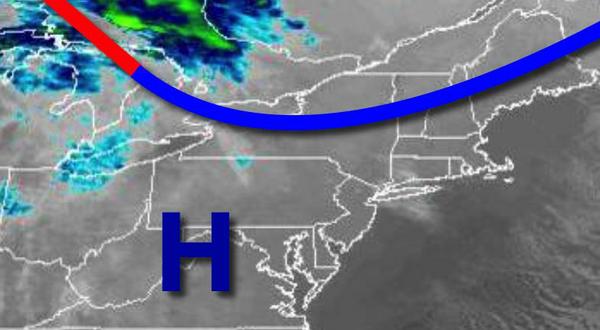
High pressure will provide excellent weather conditions today, but a powerful cold front tomorrow night will bring the threat of flash flooding, wind damage, and power outages.
High pressure will produce clear skies to scattered clouds with winds from the southwest at 5 to 15 mph. Temperatures will rise into the upper 30s to mid-40s for highs.
High pressure will exit tonight through tomorrow morning with increasing clouds through tomorrow morning. Winds will be from the southwest at 5 to 15 mph. Temperatures will fall into the lower to mid-30s over the interior and upper 30s to mid-40s along the coast for lows.
A cold front will approach tomorrow with rain developing in the afternoon and evening. The rainfall will be heavy at times in the evening. Winds will be from the southeast at 10 to 20 mph. Temperatures will rise into the mid-50s to lower 60s.
The cold front will move through the region tomorrow night through Friday morning, Christmas, with heavy rainfall, mixing with snow and sleet at times while ending. No significant snow accumulation is expected. Skies will clear in the afternoon and evening. Winds will veer from the south at 15 to 30 mph with gusts between 40 to 70 mph to the west at 10 to 20 mph with gusts over 30 mph at times. Temperatures will fall from the 50s
and 40s early in the morning into the 30s and 20s by evening.
High pressure will be in control Saturday through Monday with clear skies to scattered cloud cover. Temperatures on Saturday will range from the upper 10s to mid-20s for lows and upper 20s to mid-30s for highs. Temperatures on Sunday will range from the upper 10s to mid-20s for lows and lower to mid-30s for highs. Temperatures on Monday will range from the upper 20s to lower 30s for lows and lower to mid-40s over the interior and mid-40s
to lower 50s along the coast for highs.
An area of low pressure will move through the region on Tuesday with periods of rain and snow. Temperatures on Tuesday will range from the upper 20s to mid-30s for lows and upper 20s to lower 30s over the interior and mid to upper 30s along the coast for highs.
High pressure will be in control on Wednesday with clear skies to scattered cloud cover. Temperatures will range from the mid-10s to lower 20s for lows and upper 20s to mid-30s for highs.