A powerful cold front will bring heavy rain, powerful wind gusts, and then a flash freeze and flurries as temperatures crash through tomorrow afternoon.
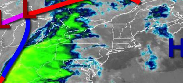
A cold front will slowly approach the region today with increasing clouds and rain towards evening. Winds will be from the southeast at 10 to 20 mph. Temperatures will rise into the mid-50s to lower 60s by this evening.
The cold front will move through the region tonight through tomorrow morning with waves of heavy rainfall. The rain will mix with sleet and snow at times as the rainfall departs. Winds will be from the south at 15 to 30 mph with gusts up to 70 mph at times. Flash flooding, urban flooding, wind damage, and power outages will be a concern, however, Santa Claus is well prepared and will be very safe. Temperatures will fall through the
50s and 40s into the 30s in this time period.
Skies will clear tomorrow afternoon as the cold front exits. A few flurries are possible, especially for the Poconos and Catskills. Winds will veer to the west at 10 to 20 mph with gusts up to 40 mph at times. Temperatures will continue to fall through the 30s and 20s.
High pressure will build into the region tomorrow night through Saturday with scattered clouds to clear skies. A few flurries and snow showers are possible due to Lake Effect Snow off of Lake Ontario and Lake Erie, mostly for the Poconos and Catskills. Winds will be from the west at 5 to 15 mph. Temperatures will range from the upper 10s to mid-2os for lows and mid-20s to lower 30s for highs.
High pressure will exit the region on Sunday with scattered clouds. Temperatures will range from the upper 10s to mid-20s for lows and mid to upper 30s for highs.
An area of low pressure will pass to the north of the region with a few widely scattered showers on Monday. Rain and snow are more likely for the Poconos. Temperatures on Monday will range from the upper 20s to lower 30s for lows and upper 30s to mid-40s over the interior and upper 40s to lower 50s along the coast for highs.
High pressure will be in control Tuesday through Thursday with scattered cloud cover. Temperatures on Tuesday will range from the lower to mid-20s over the interior and upper 20s to lower 30s along the coast for lows and mid-20s to lower 30s for highs. Temperatures on Wednesday will range from the upper 10s to mid-20s for lows and mid-30s to lower 40s for highs. Temperatures on Thursday will range from the mid-20s to lower 30s for lows
and mid to upper 40s for highs.