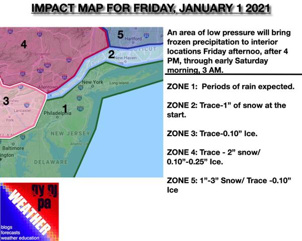
As we get ready to say goodbye to 2020, we'll have a new winter storm to kick off 2021 with the potential for significant ice for portions of the Poconos and Catskills.
An area of low pressure will approach the region on Friday, New Year's Day, with rain developing in the afternoon after 2 PM over southern New Jersey, Delaware, and Maryland. The precipitation will push into southeastern Pennsylvania where precipitation has the potential to start off as sleet and freezing rain for a short time, produce a trace of ice accretion initially before temperatures rapidly rise above freezing. Most locations in
southeastern Pennsylvania can expect only a trace before changing over to rain.
By 4 PM, the rain will be pushing north into the Philadelphia and New York City metropolitan areas. Meanwhile, snow will begin in northwestern New Jersey and northeastern Pennsylvania. The precipitation will rapidly change over to rain in northwestern New Jersey but will remain as sleet and freezing rain for much of the evening in northeastern Pennsylvania.
After 6 PM, the wintry mix will push into the Hudson River Valley and Connecticut. This precipitation will steadily change over to rain from south to north in the evening. For central and northern Connecticut, the precipitation will start off as a burst of moderate to heavy snowfall before changing over to sleet and freezing rain and then rain by 3 AM. This heavy burst will support an initial accumulation of 1" to 3" before changing over
to rain.
The primary concern for this event will be ice accretion, especially in the Poconos and Catskills, which will make travel hazardous. All precipitation will change over to rain as temperatures rise into the 40s and 50s on Saturday morning.