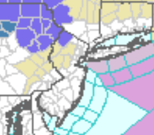
...WINTER WEATHER ADVISORY IN EFFECT FROM 2 PM FRIDAY TO 1 AM EST
SATURDAY...

* WHAT...Mixed precipitation expected. Total snow accumulations
  of up to one inch and ice accumulations of up to two tenths of
  an inch.

* WHERE...In Pennsylvania, Bradford, Susquehanna, Wyoming,
  Lackawanna and Luzerne counties. In New York, Yates, Seneca,
  Southern Cayuga, Steuben, Schuyler, Chemung, Tompkins, Tioga
  and Broome counties.

* WHEN...A mix of snow, sleet and rain will develop late in the
  afternoon New Year`s Day. The mixed precipitation will
  transition to freezing rain in the early and mid evening hours
  before changing to all rain around midnight as temperatures
  climb above freezing. Expect rain to taper to showers overnight
  into early Saturday morning.

* IMPACTS...Plan on slippery road conditions. The hazardous
  conditions could impact the evening commute.
...WINTER WEATHER ADVISORY IN EFFECT FROM 3 PM FRIDAY TO 7 AM EST
SATURDAY...

* WHAT...Mixed precipitation expected. Total snow accumulations
  of up to one inch and ice accumulations of one tenth to three
  tenths of an inch.

* WHERE...In Pennsylvania, Northern Wayne, Pike and Southern
  Wayne counties. In New York, Sullivan county.

* WHEN...A mix of snow and sleet will develop by early evening New
  Year`s Day. The precipitation will change to freezing rain in
  the evening and last into the overnight and early morning of
  Saturday. The freezing rain will taper off to a few rain showers
  by sunrise Saturday as temperatures rise above freezing.

* IMPACTS...Travel could be nearly impossible. The hazardous
  conditions could impact the evening commute New Year`s Day.