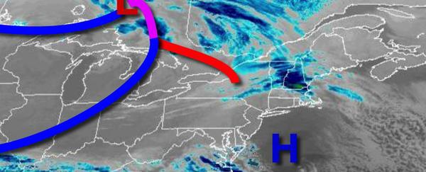
A chilly and dry weather pattern will continue through the weekend, but support is growing for a new stormy weather pattern by next week.
A series of weak troughs will move through the region today with scattered clouds. Winds will be from the southwest at 5 to 15 mph. Temperatures will rise into the upper 30s to lower 40s for highs.
A cold front will follow tomorrow with scattered clouds with a few flurries. Winds will be from the northwest at 5 to 15 mph. Temperatures tomorrow will range from the mid-20s to lower 30s for lows and mid-30s to lower 40s for highs.
High pressure will build into the region on Saturday with clear skies to scattered clouds. Winds will be from the northwest at 10 to 20 mph with gusts over 30 mph at times. Temperatures on Saturday will range from the mid to upper 10s over the interior and lower to mid-20s along the coast for lows and lower to mid-20s over the interior and upper 20s to lower 30s along the coast for highs.
High pressure will be in control Sunday through Monday afternoon with scattered clouds expected. Temperatures on Sunday will range from the mid-10s to lower 20s for lows and mid-20s to lower 30s for highs. Temperatures on Monday will range from the mid-10s to lower 20s for lows and lower to mid-30s for highs.
An area of low pressure will pass to the south of the region Monday evening through Tuesday with periods of snow, sleet, and rain for much of the region. Accumulating snowfall is a high threat for this time period. Temperatures on Tuesday will range from the upper 10s to mid-20s over the interior and upper 20s to lower 30s along the coast for lows and mid to upper 20s over the interior, upper 20s to mid-30s in the I-95 corridor, and mid-30s to
lower 40s in the southern New Jersey coast.
Scattered snow showers can be expected on Wednesday as the storm departs. Temperatures will range from the upper 10s to the lower 20s over the interior and mid to upper 20s along the coast for lows and mid to upper 20s over the interior and lower to mid-30s along the coast for highs.
High pressure will produce clear skies to scattered clouds on Thursday. Temperatures will range from the single digits to mid-10s over the interior and mid to upper 10s along the coast for lows and mid-20s to lower 30s for highs.