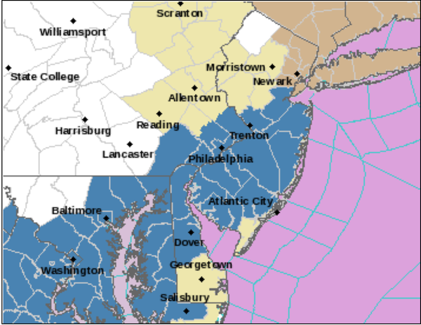
...WINTER STORM WATCH IN EFFECT FROM SUNDAY MORNING THROUGH LATE
MONDAY NIGHT...

* WHAT...Heavy snow possible. Total snow accumulations over 6
  inches possible. Winds could gust as high as 45 mph creating
  significant blowing and drifting of snow.

* WHERE...Portions of southern New Jersey, southeast
  Pennsylvania, northeast Maryland and central and northern
  Delaware.

* WHEN...From Sunday morning through late Monday night.

* IMPACTS...Travel could be very difficult. The hazardous
  conditions could impact the Monday morning or evening commutes.

* ADDITIONAL DETAILS...Snow will develop west to east Sunday
  morning and last through late Monday or early Tuesday. A period
  of wintry mix or rain could occur Sunday night and Monday
  morning before turning back to snow mid-day on Monday. The
  highest snow totals and snowfall rates are most likely to occur
  late Monday.
...WINTER STORM WATCH IN EFFECT FROM SUNDAY AFTERNOON THROUGH
LATE MONDAY NIGHT...

* WHAT...Heavy snow possible. Total snow accumulations over 7
  inches possible. Winds could gust as high as 50 mph creating
  significant blowing and drifting of snow.

* WHERE...Portions of central, northern and southern New Jersey
  and southeast Pennsylvania.

* WHEN...From Sunday afternoon through late Monday night.

* IMPACTS...Travel could be very difficult. The hazardous
  conditions could impact the Monday evening commute.

* ADDITIONAL DETAILS...Snow will develop west to east late Sunday
  and last through late Monday or early Tuesday. A period of
  wintry mix or rain could occur Sunday night and Monday morning,
  especially along and near the coast, before turning back to snow
  Monday afternoon. The highest snowfall rates are most likely to
  occur late Monday.