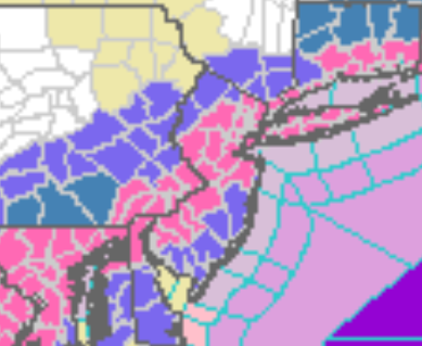
Winter Storm Warnings, Advisories, and Watches
|
...WINTER STORM WARNING IN EFFECT FROM 4 AM TO 7 PM EST SUNDAY...

* WHAT...Heavy snow expected. Total snow accumulations of 4 to 7
  inches

* WHERE...Portions of central, northern, northwest and southern
  New Jersey, southeast Pennsylvania, northeast Maryland and
  northern Delaware.

* WHEN...From 4 AM to 7 PM EST Sunday.

* IMPACTS...Travel could be very difficult particularly late
  Sunday morning and early Sunday afternoon.

* ADDITIONAL DETAILS... A heavy band of snowfall will overspread
  the area Sunday morning, with snow continuing into Sunday
  afternoon. Snowfall rates of 2 in/hr will be possible within
  this heavy band, and isolated snowfall totals in excess of 7
  inches will be possible. Snowfall will clear the area from SW-NE
  Sunday afternoon.
...WINTER STORM WARNING IN EFFECT FROM 6 AM TO 9 PM EST SUNDAY...

* WHAT...Heavy snow expected. Total snow accumulations of 5 to 9
  inches.

* WHERE...Portions of southern Connecticut and southeast New
  York.

* WHEN...From 6 AM to 9 PM EST Sunday.

* IMPACTS...Travel could be very difficult.

* ADDITIONAL DETAILS...Snowfall rates may exceed 2+ inches per
  hour for a period during the late morning and early afternoon.
...WINTER STORM WARNING IN EFFECT FROM 6 AM TO 9 PM EST SUNDAY...

* WHAT...Heavy snow expected. Total snow accumulations of 5 to 7
  inches.

* WHERE...Portions of northeast New Jersey, southern Connecticut
  and southeast New York.

* WHEN...From 6 AM to 9 PM EST Sunday.

* IMPACTS...Travel could be very difficult.

* ADDITIONAL DETAILS...Snowfall rates may exceed 1+ inches per
  hour for a period during the late morning and early afternoon.
WINTER WEATHER ADVISORIES
..WINTER WEATHER ADVISORY IN EFFECT FROM 6 AM TO 9 PM EST
SUNDAY...

* WHAT...Snow expected. Total snow accumulations of 3 to 6
  inches.

* WHERE...Portions of northeast New Jersey, southern Connecticut
  and southeast New York.

* WHEN...From 6 AM to 9 PM EST Sunday.

* IMPACTS...Plan on slippery road conditions.
...WINTER WEATHER ADVISORY IN EFFECT FROM 4 AM TO 7 PM EST
SUNDAY...

* WHAT...Wet snow expected. Total snow accumulations of up to 4
  inches.

* WHERE...Portions of central and southern New Jersey, northeast
  Maryland and central Delaware.

* WHEN...From 4 AM to 7 PM EST Sunday.

* IMPACTS...Travel could be dangerous on Sunday morning into early
  Sunday afternoon.
...WINTER WEATHER ADVISORY IN EFFECT FROM 4 AM TO 7 PM EST
SUNDAY...

* WHAT...Snow expected. Total snow accumulations of 3 to 5
  inches.

* WHERE...Portions of northern New Jersey and east central and
  northeast Pennsylvania.

* WHEN...From 4 AM to 7 PM EST Sunday.

* IMPACTS...Travel could be difficult Sunday morning through early
  Sunday afternoon.

* ADDITIONAL DETAILS...A heavy band of snowfall will overspread
  the area Sunday morning, with snow continuing into Sunday
  afternoon. Snowfall rates of 1-2 in/hr will be possible within
  this heavy band. Snowfall will clear the area from SW-NE Sunday
  afternoon.
...WINTER STORM WATCH IN EFFECT FROM SUNDAY MORNING THROUGH
SUNDAY EVENING...

* WHAT...Heavy snow possible. Total snow accumulations in excess
  of 6 inches in 12 hours possible.

* WHERE...Litchfield County, Connecticut.

* WHEN...From Sunday morning through Sunday evening.

* IMPACTS...Plan on slippery road conditions.

* ADDITIONAL DETAILS...Snowfall rates around an inch per hour
  possible late Sunday morning into the afternoon.
...WINTER STORM WATCH IN EFFECT FROM SUNDAY MORNING THROUGH LATE
SUNDAY NIGHT...

* WHAT...Heavy snow possible. Total snow accumulations of 4 to 8
  inches possible.

* WHERE...Portions of northern Connecticut, central, eastern,
  northeastern and western Massachusetts and northern Rhode
  Island.

* WHEN...From Sunday morning through late Sunday night. The
  heaviest snow will fall from late Sunday morning into Sunday
  afternoon.
SUBSCRIBE TO PREMIUM CONSULTING MEMBERSHIP FOR MORE INFORMATION
|
|