For much of this winter, almost all of the winter storms this season have featured snow changing over to rain for many locations in southern New Jersey and Delaware. However, this upcoming storm for Thursday morning through Friday afternoon will this time bring a steady snowfall to many in Atlantic City, New Jersey, and points south.
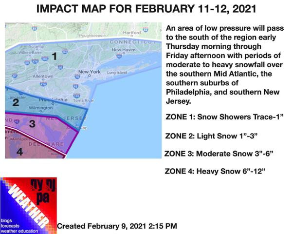
A stationary front over North Carolina and southern Virginia will support the development of several waves of low-pressure tomorrow night through Friday that will produce periods of moderate to heavy snowfall in Virginia, Maryland, and southern Delaware. Moderate snowfall will expand northward into northern Delaware and southern New Jersey with up to 6" of snow expected in these locations. Further north, periods of light snow will be possible
in southeastern Pennsylvania, the southern suburbs of Philadelphia, and south-central New Jersey for snowfall totals up to 3".
For much of the northern Philadelphia metropolitan area, central New Jersey, and the New York City metropolitan area, only scattered snow showers are a threat from this storm. Due to the very cold air expected to be in place, any snow shower will support an accumulation of a dusting to an inch at any time.
At this time, the best potential for steady snowfall over southern New Jersey will be from 3 AM to 8 AM on Thursday and 2 AM to 8 AM on Friday morning. Outside of these two time periods, periods of light snow can be expected. All snowfall will end by the late afternoon hours on Friday.
Beyond this time period, there are at least three other winter storm threats including Saturday evening into Sunday, next Tuesday night into Wednesday, and next Thursday night into Friday.