Another area of low pressure will approach on President's Day with increasing clouds and a wintry mix of snow, sleet, and freezing rain developing in the evening. Winds will be from the north at 5 to 15 mph. Temperatures will range from the lower to mid-10s over the interior, upper 10s to mid-20s in the suburbs, and mid to upper 20s along the coast for lows and mid to upper 20s over the interior and lower to mid-30s along the coast for
highs.
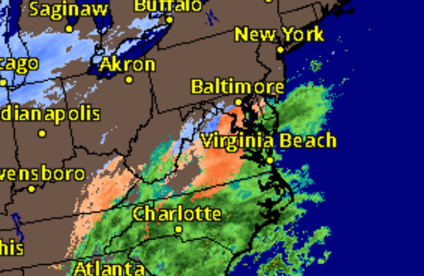
An area of low pressure will produce periods of snow over the interior, a wintry mix of snow, sleet, and freezing rain in the suburbs and along I-95, and a mix over of snow to rain along the immediate coast on Tuesday. Icy conditions are expected along and north of I-95 while snow accumulation over 4" will be possible in the Poconos and Catskills. Temperatures on Tuesday will range from the mid-20s to lower 30s for lows and mid-30s over the
interior, mid to upper 30s along I-95, and upper 30s to mid-40s along the coast.
High pressure will be in control on Wednesday with clear skies to scattered clouds. Temperatures on Wednesday will range from the lower to mid-10s over the interior and upper 10s to lower 20s along the coast for lows and lower to mid-20s over the interior and upper 20s to lower 30s along the coast for highs.
Another area of low pressure will approach on Thursday afternoon through Friday with snow over the interior, a wintery mix in the suburbs and along I-95, and a mix over to rain along the immediate coast. Temperatures on Thursday will range from the mid-10s to lower 20s over the interior and lower to mid-20s along the coast for lows and mid to upper 20s over the interior, lower to mid-30s along I-95, and upper 30s to mid-40s along the coast for
highs. Temperatures on Friday will fall through the 40s, 30, and 20s as the storm leaves.
High pressure will produce scattered clouds on Saturday. Temperatures on Saturday will range from the single digits to mid-10s over the interior and upper 10s to lower 20s along the coast for lows and mid-20s to lower 30s for highs.