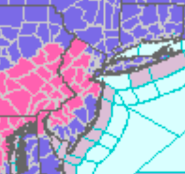
Winter Storm Warnings And Advisories
|
...WINTER STORM WARNING IN EFFECT FROM 4 AM THURSDAY TO 10 AM EST
FRIDAY...

* WHAT...Heavy mixed precipitation expected. Total snow
  accumulations of 4 to 6 inches and ice accumulations of a
  light glaze.

* WHERE...Portions of central, northern, northwest and southern
  New Jersey, southeast Pennsylvania and northern Delaware.

* WHEN...From 4 AM Thursday to 10 AM EST Friday.

* IMPACTS...Travel could be very difficult. The hazardous
  conditions could impact the Thursday morning, Thursday evening,
  and Friday morning commutes.

* ADDITIONAL DETAILS...Snow overspreads the area early Thursday
  morning and could be heavy at times in the morning and early
  afternoon. A change to sleet and freezing rain is expected by
  late afternoon or evening. Light wintry precipitation will
  likely continue into the daytime hours on Friday.
...WINTER STORM WARNING REMAINS IN EFFECT FROM 1 AM THURSDAY TO
10 AM EST FRIDAY...

* WHAT...Heavy snow expected along with a light glaze of ice.
  Total snow accumulations of 6 to 9 inches and ice
  accumulations of a light glaze.

* WHERE...Portions of central Pennsylvania.

* WHEN...From 1 AM Thursday to 10 AM EST Friday.

* IMPACTS...Travel could be very difficult. The hazardous
  conditions could impact the morning or evening commute.

* ADDITIONAL DETAILS...A period of sleet mixed with freezing
  rain is possible late Thursday afternoon which may produce a
  light glaze of ice.
...WINTER WEATHER ADVISORY IN EFFECT FROM 4 AM THURSDAY TO 10 AM
EST FRIDAY...

* WHAT...Mixed precipitation expected. Total snow accumulations of
  1 to 3 inches and ice accumulations of up to one tenth of an
  inch.

* WHERE...Portions of central and southern New Jersey, northeast
  Maryland and central Delaware.

* WHEN...From 4 AM Thursday to 10 AM EST Friday.

* IMPACTS...Plan on slippery road conditions. The hazardous
  conditions could impact the Thursday morning, Thursday evening,
  and Friday morning commutes.

* ADDITIONAL DETAILS...Snow overspreads the area early Thursday
  morning and could be heavy at times in the morning. A change to
  sleet and freezing rain is expected by afternoon. Light wintry
  precipitation will likely continue into the daytime hours on
  Friday.
...WINTER WEATHER ADVISORY IN EFFECT FROM 4 AM THURSDAY TO 10 AM
EST FRIDAY...

* WHAT...Mixed precipitation expected. Total snow accumulations
  of up to one inch and ice accumulations of a light glaze.

* WHERE...In New Jersey, Cape May. In Delaware, Inland Sussex.

* WHEN...From 4 AM Thursday to 10 AM EST Friday.

* IMPACTS...Plan on slippery road conditions. The hazardous
  conditions could impact the Thursday morning, Thursday evening,
  and Friday morning commutes.

* ADDITIONAL DETAILS...Snow or mixed precipitation overspreads the
  area early Thursday morning. A change from snow to sleet, or
  from sleet and freeing rain to plain rain, is expected through
  the day on Thursday. Light mixed precipitation will likely
  continue into the daytime hours on Friday.
...WINTER WEATHER ADVISORY IN EFFECT FROM 4 AM THURSDAY TO 7 PM
EST FRIDAY...

* WHAT...Snow expected. Snowfall accumulations of 3 to 6 inches
  are expected Thursday, with total snowfall accumulations of 5
  to 9 inches by the end of the event on Friday. A light glaze of
  ice accumulation is possible Thursday Night as well.

* WHERE...Portions of northeast New Jersey, southern Connecticut
  and southeast New York.

* WHEN...From 4 AM Thursday to 7 PM EST Friday.

* IMPACTS...Travel could be difficult. The hazardous conditions
  could impact the morning or evening commute.

* ADDITIONAL DETAILS...This will be a long duration winter
  weather event. Light to moderate snowfall is likely early
  Thursday morning into afternoon. A light wintry mix of sleet
  and/or freezing rain is possible for a period Thursday evening
  into Thursday Night, before turning back to light snow on Friday
  morning and ending in the afternoon or evening.
...WINTER WEATHER ADVISORY IN EFFECT FROM 6 AM THURSDAY TO 7 PM
EST FRIDAY...

* WHAT...Snow expected. Snowfall accumulations of 3 to 5 inches
  are expected Thursday, with total snowfall accumulations of 4 to
  8 inches by the end of the event on Friday.

* WHERE...Northeastern Suffolk, Southwestern Suffolk and
  Southeastern Suffolk Counties.

* WHEN...From 6 AM Thursday to 7 PM EST Friday.

* IMPACTS...Plan on slippery road conditions. The hazardous
  conditions could impact the morning or evening commute.

* ADDITIONAL DETAILS...This will be a long duration winter
  weather event. Light to moderate snowfall is likely Thursday
  morning into afternoon. A light wintry mix of sleet and/or rain
  is likely for a period Thursday evening into Thursday Night,
  particularly the south fork of Long Island. Precipitation is
  expected to turn back to light snow on Friday morning before
  ending in the evening.
...WINTER WEATHER ADVISORY IN EFFECT FROM 6 AM THURSDAY TO 7 PM
EST FRIDAY...

* WHAT...Snow expected. Snowfall accumulations of 3 to 5 inches
  are expected Thursday, with total snowfall accumulations of 5 to
  8 inches by the end of the event on Friday.

* WHERE...Portions of southern Connecticut.

* WHEN...From 6 AM Thursday to 7 PM EST Friday.

* IMPACTS...Plan on slippery road conditions. The hazardous
  conditions could impact the morning or evening commute.

* ADDITIONAL DETAILS...This will be a long duration winter weather
  event. Light to moderate snowfall is likely Thursday morning
  into evening. Periods of light snow are then expected Thursday
  Night into Friday afternoon, before ending in the evening.
...WINTER WEATHER ADVISORY IN EFFECT FROM 4 AM THURSDAY TO 7 PM
EST FRIDAY...

* WHAT...Snow expected. Snowfall accumulations of 3 to 6 inches
  are expected Thursday, with total snowfall accumulations of 5
  to 9 inches by the end of the event on Friday.

* WHERE...Portions of northeast New Jersey, southern Connecticut
  and southeast New York.

* WHEN...From 4 AM Thursday to 7 PM EST Friday.

* IMPACTS...Travel could be very difficult. The hazardous
  conditions could impact the morning or evening commute.

* ADDITIONAL DETAILS...This will be a long duration winter weather
  event. Light to moderate snowfall is likely early Thursday
  morning into afternoon. Periods of light snow are then expected
  Thursday Night into Friday morning, before ending in the
  afternoon.
...WINTER WEATHER ADVISORY IN EFFECT FROM 3 AM THURSDAY TO 7 PM
EST FRIDAY...

* WHAT...Snow expected. Total snow accumulations of 4 to 7
  inches.

* WHERE...In Pennsylvania, Pike and Wayne counties. In New York,
  Sullivan county.

* WHEN...From 3 AM Thursday to 7 PM EST Friday.

* IMPACTS...Travel could be very difficult. The hazardous
  conditions could impact commutes starting with Thursday
  morning.

* ADDITIONAL DETAILS...Snowfall rates will generally be light at
  the outset as incoming precipitation works against some
  lingering dry air. A brief lull is possible late Thursday
  afternoon with another steadier bout of light to moderate snow
  moving back into the area Thursday night into Friday.
SUBSCRIBE TO PREMIUM CONSULTING MEMBERSHIP FOR MORE INFORMATION
|
|