Winter Weather Advisory For Tomorrow
|
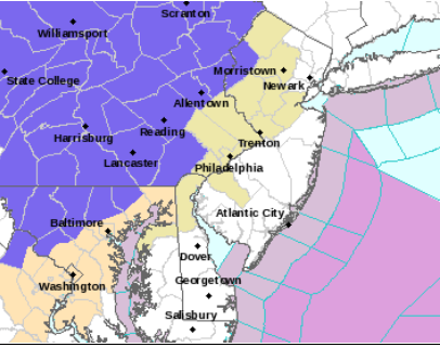
..WINTER WEATHER ADVISORY IN EFFECT FROM 9 AM TO 6 PM EST
MONDAY...

* WHAT...Snow expected. Total snow accumulations of 3 to 5
  inches.

* WHERE...Carbon and Monroe.

* WHEN...From 9 AM to 6 PM EST Monday.

* IMPACTS...Plan on slippery road conditions. The hazardous
  conditions could impact the morning or evening commute.

* ADDITIONAL DETAILS...Much of the snow could come in a quick 1 to
  3 hour burst late morning to early afternoon, causing conditions
  to rapidly deteriorate. During this time, snow rates of one inch
  per hour or more are possible.
...WINTER WEATHER ADVISORY IN EFFECT FROM 9 AM TO 6 PM EST
MONDAY...

* WHAT...Snow expected. Total snow accumulations of 2 to 4
  inches.

* WHERE...In New Jersey, Warren. In Pennsylvania, Berks, Lehigh
  and Northampton.

* WHEN...From 9 AM to 6 PM EST Monday.

* IMPACTS...Plan on slippery road conditions. The hazardous
  conditions could impact the morning or evening commute.

* ADDITIONAL DETAILS...Much of the snow could come in a quick 1 to
  3 hour burst late morning to early afternoon, causing conditions
  to rapidly deteriorate. During this time, snow rates of one inch
  per hour or more are possible.
...WINTER WEATHER ADVISORY IN EFFECT FROM 9 AM TO 6 PM EST
MONDAY...

* WHAT...Snow expected. Total snow accumulations of two to three
  inches.

* WHERE...Western Chester and Eastern Chester.

* WHEN...From 9 AM to 6 PM EST Monday.

* IMPACTS...Plan on slippery road conditions. The hazardous
  conditions could impact the morning or evening commute.

* ADDITIONAL DETAILS...Much of the snow could come in a quick 1 to
  3 hour burst late morning to early afternoon, causing conditions
  to rapidly deteriorate. During this time, snow rates of one inch
  per hour or more are possible.
...WINTER WEATHER ADVISORY IN EFFECT FROM 9 AM TO 6 PM EST
MONDAY...

* WHAT...Snow expected. Total snow accumulations of 3 to 5 inches
  at higher elevations, and 1 to 3 inches in valleys. Winds
  gusting as high as 30 mph at higher elevations.

* WHERE...Wyoming, Lackawanna, Luzerne, Pike and Southern Wayne
  counties.

* WHEN...From 9 AM to 6 PM EST Monday.

* IMPACTS...Plan on slippery road conditions. The hazardous
  conditions could impact the morning or evening commutes.

* ADDITIONAL DETAILS...Though light snow may occur in early
  morning, snow becomes heavier mid morning through early
  afternoon, with snowfall rates up to one inch per hour at times.
  Snow will become lighter in late afternoon before ending.
...WINTER WEATHER ADVISORY IN EFFECT FROM 8 AM TO 3 PM EST
MONDAY...

* WHAT...Snow expected. Total snow accumulations of 1 to 3 inches,
  with up to 4 inches possible across the higher terrain along
  Interstate 81 in Schuylkill County and over Sullivan County.
  Winds gusting from the south up to 30 mph on the ridges.

* WHERE...Portions of central Pennsylvania.

* WHEN...From 8 AM to 3 PM EST Monday.

* IMPACTS...Plan on slippery road conditions. The hazardous
  conditions could impact the morning commute.

* ADDITIONAL DETAILS...The snow could be heavy at times, and fall
  around one inch per hour during the late morning and early
  afternoon hours.
SUBSCRIBE TO PREMIUM CONSULTING MEMBERSHIP FOR MORE INFORMATION
|
|