The first day of meteorological Spring will feature waves of rainfall this morning, but a brief arctic blast will visit tonight with the potential for a few snow showers for Poconos and Catskills.
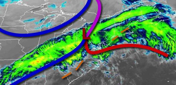
A strong cold front will drive through the region this morning with waves of rain, heavy at times. The rain will exit from west to east early this afternoon. Winds will veer to the northwest at 10 to 20 with gusts over 30 mph at times. Temperatures will rise into the lower to mid-40s over the interior and upper 40s to lower 50s along the coast for highs.
The cold front will clear the region this evening, but a few flurries and snow showers will linger over the Poconos, Catskills, northwestern New Jersey, and the Hudson River Valley tonight. Snow accumulation of a dusting to an inch can be expected for elevations above 1,000 feet. Otherwise, scattered clouds can be expected for the rest of the region. Winds will be from the northwest at 15 to 30 mph with gusts over 40 mph at times.
Temperatures will fall into the lower to mid-10s over the interior and mid to upper 10s along the coast for lows but will feel like the single digits.
High pressure will build into the region tomorrow with clear skies to scattered clouds. Winds will be from the northwest at 10 to 20 mph with gusts over 30 mph at times. Temperatures will rise into the mid-20s over the interior and upper 20s to lower 30s along the coast for highs but will feel like the 10s.
High pressure will be in control on Wednesday with clear skies to scattered clouds. Winds will be from the west at 5 to 15 mph. Temperatures will range from the upper 10s to mid-20s for lows and mid to upper 40s for highs.
High pressure will be in control Thursday through Monday with clear skies to scattered cloud cover as a series of weak low-pressure systems remain well to the south and southeast of the region. Temperatures on Thursday will range from the lower to mid-20s over the interior and upper 20s to lower 30s along the coast for lows and lower to mid-30s over the interior and upper 30s to mid-40s along the coast for highs. Temperatures on Friday will
range from the lower to mid-10s over the interior and upper 10s to lower 20s along the coast for lows and lower to mid-30s for highs. Temperatures on Saturday will range from the lower to mid-10s over the interior and upper 10s to mid-20s along the coast for lows and upper 30s to lower 40s for highs. Temperatures on Sunday will range from the mid-10s to lower 20s over the interior and mid to upper 20s along the coast for lows and lower to mid-30s over the interior and upper 30s to
lower 40s along the coast for highs. Temperatures on Monday will range from the single digits to lower 10s over the interior and mid to upper 10s along the coast for lows and upper 20s over the interior and lower to mid-30s along the coast for highs.