After a cool start, warm weather returns for the rest of the week along with the threat of a few showers.
High pressure will pass off the coast with scattered clouds. Winds will be from the southwest at 5 to 15 mph. Temperatures will rise into the lower to mid-40s for highs this afternoon.
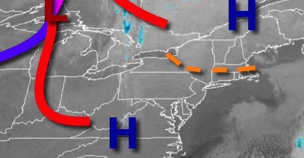
A weak cold front will drop through the region tomorrow with scattered clouds and an isolated shower possible. Winds will veer from the southwest to northwest at 5 to 15 mph. Temperatures will range from the lower to mid-30s for lows and upper 40s to lower 50s over the interior and mid-50s to lower 60s along the coast for highs.
High pressure will produce scattered clouds on Wednesday. Winds will veer to the southeast at 5 to 15 mph. Temperatures on Wednesday will range from the mid to upper 20s over the interior and lower to mid-30s along the coast for lows and upper 40s to lower 50s along the immediate coast, mid to upper 50s over the interior, and upper 50s to lower 60s in the Delaware River Valley.
A warm front will follow on Thursday with scattered to broken clouds and isolated showers. Temperatures on Thursday will range from the lower to mid-40s for lows and mid to upper 50s along the immediate coast, lower to mid-60s over the interior, and mid-60s to lower 70s in the Delaware River Valley for highs.
A cold front will slowly dive through the region with broken clouds and scattered showers on Friday. Temperatures will range from the upper 40s to lower 50s for lows and upper 50s to mid-60s for highs.
High pressure will be in control on Saturday through Monday with clear skies to scattered clouds. Temperatures on Saturday will range from the mid-20s to lower 30s over the interior and mid-30s to lower 40s along the coast for lows and upper 30s to lower 40s over the interior and mid to upper 40s along the coast for highs. Temperatures on Sunday will range from the mid-20s to lower 30s for lows and upper 30s to mid-40s over the interior and
mid-40s to lower 50s along the coast for highs. Temperatures on Monday will range from the upper 10s to mid-20s for lows and lower to mid-40s for highs.