An onshore wind pattern through the next several days will produce an increase of cloud cover and that threat for drizzle and showers.
High pressure off the New England coast will produce clear skies to scattered clouds. Winds will be from the east at 5 to 15 mph. Temperatures will rise into the mid-50s to lower 60s for highs.
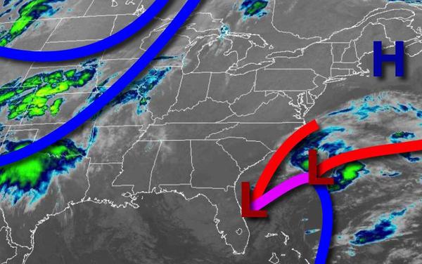
An area of low pressure off the coast of the Mid Atlantic and high pressure off the New England coast tonight through Wednesday with broken to overcast cloud cover, drizzle, and isolated showers. Winds will be from the east-southeast at 5 to 15 mph. Temperatures tomorrow will range from the lower to mid-30s over the interior and mid-30s to lower 40s along the coast for lows and upper 50s to mid-60s for highs. Temperatures on Wednesday
will range from the upper 30s to mid-40s for lows and mid to upper 50s for highs.
A trough will pass through the region on Thursday with broken to overcast cloud cover and isolated showers. Temperatures on Thursday will range from the upper 40s to mid-50s for lows and mid-60s along the immediate coast and upper 60s to lower 70s elsewhere for highs.
A strong cold front will move through the region on Friday with scattered showers. Temperatures will range from the upper 40s to mid-50s for lows and mid-60s along the coast and upper 60s to mid-70s elsewhere for highs.
A series of cold fronts will follow Saturday through Monday with scattered to broken cloud cover and widely scattered showers. Temperatures on Saturday will range from the lower to mid-40s over the interior and upper 40s to lower 50s along the coast for lows and mid to upper 50s over the interior and upper 50s to mid-60s elsewhere for highs. Temperatures on Sunday will range from the upper 30s to mid-40s for lows and mid-40s to lower 50s along
the coast and mid to upper 50s elsewhere for highs. Temperatures on Monday will range from the mid-30s to lower 40s for lows and upper 30s to mid-40s over the interior, lower to mid-40s along the coast, and mid-40s to lower 50s elsewhere for highs.