Locally dense fog will slowly burn off after 9 AM this morning, giving way to sunny and warm conditions. A cold front tomorrow brings the threat for morning showers and thunderstorms.
Dense fog with visibility below a mile in many locations this morning will begin to lift after 9 AM. The fog will give way to scattered clouds to clear skies this afternoon. Winds will be from the south at 5 to 15 mph. Temperatures will rise into the mid to upper 60s along the coast and lower to mid-70s elsewhere for highs this afternoon.
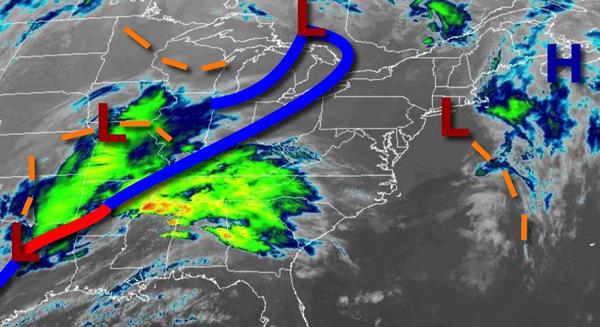
A cold front will approach tonight with increasing clouds and showers developing towards tomorrow morning. Winds will be from the south at 5 to 15 mph. Temperatures will fall into the upper 40s to mid-50s along the coast and mid-50s to lower 60s elsewhere for lows.
The cold front will move through the region tomorrow with periods of showers and isolated thunderstorms tomorrow morning. The thunderstorms will be capable of occasional lightning, heavy downpours, and wind gusts over 40 mph. Skies will clear in the afternoon. Winds will veer from the south to west at 10 to 20 mph with gusts over 25 mph at times. Temperatures will rise into the upper 60s to lower 70s along the immediate coast, upper
60s to mid-70s over the interior, and mid-70s to lower 80s elsewhere for highs.
A weak trough will follow on Saturday with scattered clouds and an isolated shower possible. Winds will be from the south at 5 to 15 mph. Temperatures will range from the upper 30s to mid-40s for lows and upper 50s to mid-60s along the coast, lower to mid-60s over the interior, and mid to upper 60s in the Delaware River Valley for highs.
An area of low pressure will move through the region on Sunday with periods of showers, especially in the afternoon. Temperatures will range from the mid-40s to lower 50s for lows and mid-50s to lower 60s along the coast and lower to mid-60s elsewhere for highs.
High pressure will build into the region on Monday with scattered clouds and windy conditions. Temperatures will range from the mid-30s to lower 40s for lows and mid-40s to lower 50s along the coast and lower to mid-50s elsewhere for highs.
High pressure will pass over the region on Tuesday with clear skies to scattered clouds. Temperatures will range from the upper 20s to mid-30s for lows and upper 40s to mid-50s along the coast, lower to mid-50s over the interior, and mid-50s to lower 60s in the Delaware River Valley.
A series of cold fronts will follow on Wednesday and Thursday with isolated to widely scattered showers. Temperatures on Wednesday will range from the lower to mid-40s over the interior and mid to upper 40s along the coast for lows and upper 50s to mid-60s along the coast and mid-60s to lower 70s elsewhere for highs. Temperatures on Thursday will range from the mid-30s to lower 40s over the interior and mid to upper 40s along the coast for lows
and lower to mid-40s for higher elevations, mid-40s to lower 50s for the interior of the interior, mid-50s to lower 60s along the coast, and lower to mid-60s in the Delaware River Valley.