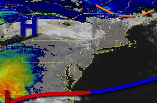
While excellent weather will be in place today, heavy rain and even thunderstorms will be a threat tomorrow as a low-pressure system moves through.
High pressure will produce clear skies to scattered cloud cover today. Winds will be from the west at 5 to 15 mph. Temperatures will rise into the upper 50s to lower 60s on the coast, lower to mid-60s over the interior, and mid to upper 60s elsewhere for highs.
Clouds will increase tonight as an area of low pressure will approach the region. Winds veer to the southeast at 5 to 15 mph. Temperatures will fall into the mid-40s to lower 50s for lows.
A warm front will lift through the region tomorrow morning with periods of rain, heavy at times. A cold front will follow in the afternoon with additional showers and a few embedded thunderstorms. The thunderstorms will be capable of heavy downpours, occasional lightning, small hail, and wind gusts over 40 mph. Winds will veer from the south to southwest at 10 to 20 mph. Temperatures will rise into the upper 50s to lower 60s on the
coast, lower to mid-60s over the interior, and mid-60s to lower 70s elsewhere for highs.
High pressure will build into the region on Monday with clearing skies. Winds will be from the northwest at 5 to 15 mph. Temperatures will range from the mid to upper 30s over the interior and lower to mid-40s along the coast for lows and upper 40s to mid-50s for highs.
High pressure will exit on Tuesday with increasing clouds throughout the day. Temperatures will range from the mid to upper 30s for lows and mid-50s to lower 60s on the immediate coast and lower to mid-60s elsewhere for highs.
A series of cold fronts will follow on Wednesday and Thursday with periods of showers, heavy at times. Temperatures on Wednesday will range from the mid to upper 40s for lows and mid-50s to lower 60s for highs. Temperatures on Thursday will range from the upper 20s to mid-30s over the interior and mid to upper 30s along the coast for lows and lower to mid-30s over the interior and upper 30s to mid-40s along the coast for
highs.
High pressure will be in control on Friday and Saturday with clear skies expected. Temperatures on Friday will range from the mid-10s to lower 20s over the interior and mid to upper 20s along the coast for lows and upper 20s to lower 30s over the interior and mid-30s to lower 40s along the coast for highs. Temperatures on Saturday will range from the single digits to mid-10s over the interior and upper 10s to mid-20s for lows and lower to
mid-40s over the interior and upper 40s to lower 50s along the coast for highs.