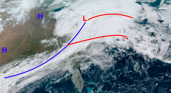
Highlights: Batches to moderate and locally heavy rain this morning will become more scattered in nature for the early afternoon. A strong line of storms associated with a cold front will push through the region from east to west this evening, starting with the interior around 5 pm and will push through the coast around 8-9 pm. Thunderstorm threats include heavy rain, gusty winds, and a minimal yet non-zero chance of a tornado.
Sunday: A wet yet warm day is expected, with high temperatures in the mid to upper 50s for the far interior, as well as immediate coastal regions. Between the coast and central/eastern portions of Pennsylvania, temperatures will likely spike into the mid-60s to low 70s for a time as strong south-southwesterly winds impact the area (10-25 mph).
A line of thunderstorms is expected to form along the approaching cold front as it pushes into this relatively warm and moist airmass. The storms will begin to form in central/eastern Pennsylvania around the 3-5 pm timeframe. The storms will then approach eastern Pennsylvania, the Philadelphia Metro area, and western portions of New Jersey around the 6-7 pm timeframe. Storms will reach the coast and NYC Metro around 7-9 pm this evening.
Impacts of storms Sunday: Although a widespread severe thunderstorm outbreak is not expected, these thunderstorms will likely bring heavy rain, scattered gusty winds (>40 mph), and a small chance of an isolated tornado. Areas where it will be warmer, such as the Philadelphia Metro area and Southern New Jersey have a higher risk of severe weather. Be sure to stay informed as the storms move through this
evening.
Sunday Night into Monday: After storms pass early this evening, some scattered rain may be possible before midnight. Gusty winds will likely continue as colder air rushes in behind the cold front (sustained 10-20 mph, gusts 25-35 mph). Temperatures will drop into the low to mid-30s for the interior and mid-30s to low 40s for the coast.
Monday: A sunny and breezy day is expected, with temperatures pushing into the low to mid-40s for the interior and mid to upper 40s for the coast. Winds will be out of the west-northwest at around 10-20 mph but will weaken throughout the day.
Monday Night into Tuesday: A calm and clear night is expected, with temperatures falling into the low to mid-30s region wide as a high-pressure system sits overhead.
Tuesday: Another nice day is expected as a southerly wind pulls in above-average temperatures. Areas such as coastal New Jersey and Long Island may only see temperatures in the mid-50s as more interior locations get into the upper 50s to mid-60s. Some clouds may build in from the west during the second half of the day.
Tuesday Night into Wednesday: Temperatures in the low to mid-40s for the interior and mid to upper 40s for the coast are expected.
Wednesday: Another front will approach the region and bring areas of rain for the late morning into the afternoon. Temperatures will warm into the upper 50s and mid-60s ahead of the front, with potentially warmer temperatures possibly as strong southerly winds are expected. Coastal locations will likely remain cooler with winds off of the ocean.
Wednesday Night into Thursday: Winds will turn out of the northwest as colder air surges into the region. Lows in the low 30s for the interior and upper 30s for the coast is expected. Also, the potential for some interior snow showers needs to be watched as this cold air moves in. The exact details are too far out to be discussed, so stay tuned for updates as the week goes on.
Thursday: As cold air continues to push into the region, high temperatures will not budge much out of the low to mid-30s for the interior and low 40s for the coast. Scattered rain and snow showers are possible.
Thursday Night into Friday: A subfreezing night for the entire region may be possible, with lows in the upper 20s to low 30s for the coast and upper teens to mid-20s for the interior.
Friday: Temperatures in the low to mid-30s for the interior and upper 30s to mid-40s for the coast is expected.
Weekend: Some uncertainty remains but temperatures will likely be near to below normal for the weekend, with scattered potential for precipitation as well.
- Intern Meteorologist Michael Browne