An area of low pressure will bring waves of rainfall to the region this evening through tomorrow with some snow over the interior. An active weather pattern continues into next week.
An area of low pressure will approach today with increasing clouds through this morning with showers developing in the afternoon. Winds will be from the southeast at 5 to 15 mph. Temperatures will rise into the upper 50s to lower 60s over the interior, mid-50s to lower 60s along the coast, and lower to mid-60s in the Delaware River Valley for highs.
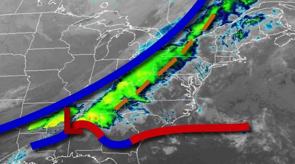
The area of low pressure will lift through the region tonight with periods of rain, heavy at times. A few embedded thunderstorms will be possible along the immediate coast with intense downpours and wind gusts up to 40 mph. The rain will mix over to snow in the Poconos and Catskills towards morning with snow accumulation of a trace to 2", especially for elevations over 1,500 feet. Rainfall amounts of 0.25" to 0.75" can be expected over
the interior, 0.5" to 1.5" in the Delaware River Valley, and 1.5" to 2.0" along the immediate coast. Winds will back from the south to northeast at 5 to 15 mph. Temperatures will fall into the upper 20s to mid-30s over the interior and upper 30s to lower 40s along the coast.
The low-pressure system will exit into New England tomorrow with periods of rain along the coast and snow in the Poconos and Catskills in the morning hours. Skies will clear in the afternoon and evening. Winds will back to the northwest at 10 to 20 mph with gusts over 30 mph at times. Temperatures will rise into the upper 30s to lower 40s over the interior and mid-40s to lower 50s along the coast for highs.
High pressure will build into the region on Friday with clearing skies. Winds will be from the northwest at 5 to 15 mph. Temperatures on Friday will range from the upper 10s to mid-20s over the interior and upper 20s to lower 30s along the coast for lows and lower to mid-30s over the interior and upper 30s to lower 40s along the coast for highs.
High pressure will pass over the region on Saturday with clear skies to scattered clouds. Temperatures will range from the lower to mid-20s over the interior and upper 20s to lower 30s along the coast for lows and upper 40s to lower 50s for highs.
A weak trough will pass through the region on Sunday, Easter, with scattered clouds with isolated showers. Temperatures will range from the lower to mid-30s over the interior and mid-30s to lower 40s along the coast for lows and upper 40s to lower 50s over the interior, lower to mid-50s on Long Island, and mid-50s to lower 60s elsewhere for highs.
A series of weak troughs will pass through the region Monday through Wednesday with scattered clouds and isolated showers. Most locations will remain dry through the forecast period. Temperatures will range from the lower to mid-30s over the interior and upper 30s to lower 40s along the coast for lows and upper 40s to mid-50s over the interior and mid-50s to lower 60s along the coast for highs.