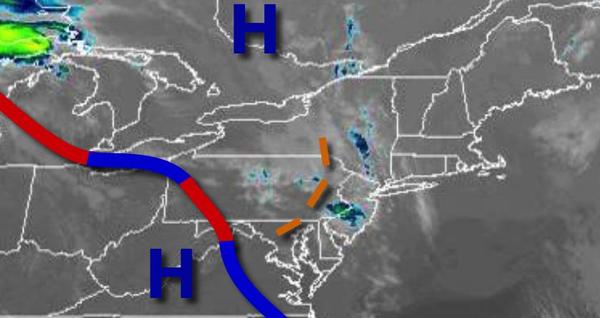
After a stretch of dry weather, the threat for rainfall slowly returns to the region as a stationary front lingers over the Mid Atlantic.
A stationary front will linger to the south of the region today as a trough passes through the region with isolated showers in the morning followed by scattered to broken cloud cover. Winds will veer from the northwest to north at 5 to 15 mph. Temperatures will rise into the lower to mid-60s for highs.
The stationary front will waver over the region tonight through Friday with scattered to broken clouds and isolated showers. The showers will be capable of brief heavy downpours. Winds will veer from the northeast to east through the period at 5 to 15 mph. Temperatures tomorrow will range from the lower to mid-40s for lows and lower to mid-60s on the coast and mid-60s to lower 70s elsewhere for highs. Temperatures on Friday will
range from the upper 30s to lower 40s for lows and upper 50s to lower 60s for highs.
The stationary front will linger over the region on Saturday with scattered to broken clouds and isolated to widely scattered showers. Temperatures on Saturday will range from the lower to mid-40s along the immediate coast and mid-40s to lower 50s elsewhere for lows and upper 50s to mid-60s along the coast and mid to upper 60s elsewhere for highs.
An area of low pressure will lift a warm front through the region on Sunday with periods of rain, heavy at times, especially in the morning hours. Temperatures will range from the lower to mid-50s for lows and mid-50s to lower 60s along the immediate coast, upper 50s to mid-60s over the interior, and mid-60s to lower 70s in the Delaware River Valley.
A series of low-pressure systems and weak cold fronts will follow Monday through Wednesday with scattered to broken clouds and isolated to widely scattered showers. Temperatures on Monday will range from the lower to mid-40s for lows and upper 40s to mid-50s for highs. Temperatures on Tuesday will range from the upper 30s to lower 40s for lows and mid-50s to lower 60s for highs. Temperatures on Wednesday will range from the upper 30s to
mid-40s for lows and mid to upper 50s over the interior and lower to mid-60s along the coast for highs.