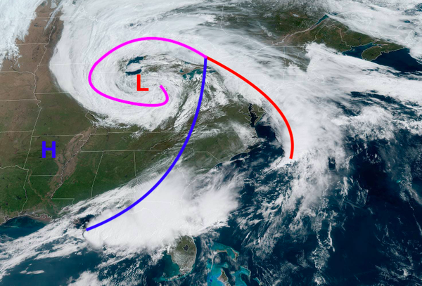
Highlights: A sprawling low-pressure system across the southern Great Lakes is bringing an area of rain that is moving north through the center of the region. As the associated warm front moves through, conditions will be favorable for some thunderstorms and downpours later in the afternoon for southern portions of the forecast area. Temperatures will steadily cool from above-normal temperatures to slightly below normal temperatures
throughout the week.
Sunday: Widespread light rain for eastern interior areas and much of the coastal plain has become more scattered and spotty in nature. Scattered showers and isolated pockets of moderate rain are expected to impact the New York City metro areas and northern and eastern portions of New Jersey throughout the afternoon.
Temperatures in the mid-50s to low 60s are expected throughout much of the region as showers and clouds stick around with an east wind at 5-15 mph. With that, southern portions of New Jersey and southeastern Pennsylvania could make a run for 70 degrees as clouds attempt to clear and winds become more southerly.
Sunday Evening through Monday Morning: With warm temperatures and dewpoints in the low 60s, the potential for thunderstorms to form late this evening and early tonight is possible. Around 8-10 pm, thunderstorms are expected to form in southern Pennsylvania and southwestern New Jersey. These storms should quickly weaken as they head northeast through New Jersey, with the main threat being heavy rain, some gusty winds, and a few rumbles of
thunder.
Temperatures are expected to fall into the low to mid-40s regionwide as winds out of the northeast become a bit stronger at about 10-15 mph, with gusts around 20 possible near the coast. Cloudy skies with areas of showers and isolated pockets of moderate rain are expected to continue for most of the region.
Monday: Temperatures in the low to mid-40s for the interior and mid to upper 40s for the coast are expected. Winds out of the northeast will continue but are expected to weaken throughout the day. Continued areas of showers and rain are expected to continue mainly for areas such as Long Island, northern New Jersey, and northeastern Pennsylvania due to the placement of the warm front. If you arent seeing rain, expect mostly cloudy
skies.
Monday Night into Tuesday: Showers and rain will finally begin to dissipate through the first half of the night as the low-pressure system finally slides out of the region. Temperatures in the upper 30s to low 40s are expected for the interior and low to mid-40s for the coast.
Tuesday: Temperatures in the upper 40s to low 50s for the interior and mid to upper 50s for the coast is expected with partly to mostly cloudy skies. Immediate coastal areas could see cooler temperatures due to ocean influences.
Tuesday Night into Wednesday: Temperatures in the low to mid-50s for the interior and mid to upper 50s for the coast are expected. The potential for temperatures to push into the low 60s in southern portions of the forecast region is possible but not guaranteed. Immediate coastal locations will likely remain colder again due to ocean influences.
Rain showers may begin to build into interior portions of the forecast region as another low-pressure system approaches.
Wednesday Night into Thursday: Areas of light rain are possible overnight as temperatures fall into the mid to upper 40s for the coast and low to mid-40s for the interior.
Thursday: Areas of rain and showers are expected to continue as the low-pressure stalls in the vicinity of the forecast region. Temperatures in the upper 30s to mid-40s for the interior and mid to upper 40s for the coast are expected. Some uncertainty still remains due to being about 4 days out, so stay tuned for more up-to-date forecasts.
Thursday Night into Friday: Rain showers continue with temperatures in the upper 30s t low 40s for the interior and low to mid-40s for the coast.
Friday: The potential for rain showers continue, but should decrease as the day goes on. High temperatures in the mid-40s for the interior and upper 40s to low 50s for the coast are expected.
Weekend: A mainly dry and cool weekend with temperatures in the 50s for highs and 40s for lows is in the forecast. The forecast will become more detailed as the weekend approaches.
- Intern Meteorologist Michael Browne