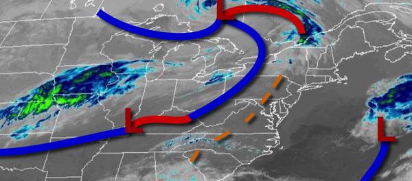
Warm and tranquil conditions today will give way to the threat of strong to severe thunderstorms tomorrow afternoon as a cold front presses through the region. Another rain threat returns for Sunday.
A cold front will slowly sink through the region this afternoon with scattered clouds and a few isolated showers. Winds will be from the southwest at 5 to 15 mph. Temperatures will rise into the lower to mid-60s over the interior and mid-60s to lower 70s elsewhere for highs.
The cold front will stall over the region tonight through tomorrow morning with scattered to broken clouds and isolated showers. Winds will be from the south at 5 to 15 mph. Temperatures will fall into the mid-40s to lower 50s over the interior and lower to mid-50s along the coast for lows.
An area of low pressure will pass through the region tomorrow afternoon with showers and strong to severe thunderstorms. The best potential for severe thunderstorms will be in the Delaware River Valley with thunderstorms capable of heavy downpours, frequent lightning, and wind gusts over 60 mph between 12 PM to 6 PM. Winds will veer from the south to northwest at 10 to 20 mph with gusts over 25 mph at times. Temperatures will rise into
the upper 50s to mid-60s over the interior, lower to mid-60s on the immediate coast, and mid-60s to lower 70s in the Delaware River Valley for highs.
High pressure will build into the region on Thursday with clearing skies. Winds will be from the northwest at 10 to 20 mph with gusts over 30 mph at times. Temperatures on Thursday will range from the mid-20s to lower 30s over the interior and lower to mid-30s along the coast for lows and lower to mid-40s over the interior and mid to upper 40s along the coast for highs.
High pressure will pass through the region on Friday and Saturday with clear skies to scattered clouds. Temperatures on Friday will range from the lower to mid-30s over the interior and mid to upper 30s along the coast for lows and mid to upper 50s over the interior and upper 50s to lower 60s along the coast for highs. Temperatures on Saturday will range from the mid to upper 30s over the interior and lower to mid-40s along the coast for lows
and lower to mid-60s for highs.
An area of low pressure will produce periods of rain, heavy at times, on Sunday. Temperatures will range from the lower to mid-40s over the interior and upper 40s to lower 50s along the coast for lows and lower to mid-50s for highs.
High pressure will be in control on Monday and Tuesday with clear skies to scattered cloud cover. Temperatures on Monday will range from the lower to mid-30s over the interior and upper 30s to mid-40s along the coast for lows and upper 40s to lower 50s over the interior and mid to upper 50s for highs. Temperatures on Tuesday will range from the lower to mid-30s over the interior and upper 30s to mid-40s along the coast for lows and upper 50s to
lower 60s over the interior and mid-60s to lower 70s along the coast for highs.